Khirbet Kerak
The tell of Khirbet Kerak lies where the Sea of Galilee empties into the Jordan River and the terrain rises by c. 15 meters above the level of the lake.
[10] Though it is not mentioned in the Hebrew Bible or other Bronze or Iron Age sources,[2] the name may preserve, at least in part, the Canaanite toponym of Ablm-bt-Yrh, "the city/fort (qrt) of his-majesty Yarih".
Abel), this location is mentioned in the 14th century BCE Epic of Aqhat, and is thought to be a reference to the Early Bronze Age structure extant at Khirbet Kerak.
[11] The name Bet Yerah has generally been accepted and applied to the site of Khirbet Kerak, though the evidence for its being located there is circumstantial.
[12] The 2009 discovery at the tell of a stone palette with Egyptian motifs, including an ankh,[13] points to trade/political relations with the First dynasty of Egypt, at approximately 3000 BCE.
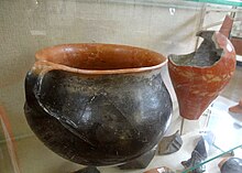
[16][17] The basalt houses belong to the same phase as the Khirbet al-Kerak pottery, dated to the Early Bronze Age III.
From the earliest phases, the settlement was protected from the south and west by a city wall (the north and east facing the Sea of Galilee).
[23] It was given the Greek name Philoteria by Ptolemy II Philadelphus for his sister, as indicated by remains dating to the Ptolemaic rule (3rd century BCE).
[23][24] Hellenistic remains identified as those of ancient Philoteria by Amihai Mazar consist of "a considerable number of spacious town-houses built on an orthogonal plan within the confines of the Early Bronze Age fortifications.
[30] An Arab Islamic palatial complex or qasr in al-Sinnabra, known by the same name, served as a winter resort to Mu'awiya, Marwan I, and other caliphs in Umayyad-era Palestine (c. 650-704 CE).
[32][33][34] For decades, part of this complex was misidentified as a Byzantine-era (c. 330-620 CE) synagogue; excavations carried out in 2010 confirmed an architectural analysis made by Donald Whitcomb in 2002 suggesting the building to be the qasr of al-Sinnabra.
[44] [45] In 1933, Na'im Makhouly, a Christian Palestinian from Nazareth, who was an inspector for the Mandate Department of Antiquities at the time of the construction of the Samak-Tiberias highway that cut across the tell, conducted a salvage excavation.
Guy and Pesach Bar-Adon, two Israeli archaeologists excavated the compound, falsely identifying a building there as a 5th-6th century synagogue, because of the presence of a column base engraved with a seven-branched candelabrum.
[33][37][39][40] Excavations by the Oriental Institute of the University of Chicago led by Pinhas Delougaz and Richard C. Haines in 1952-1953 uncovered a Byzantine church to the north of the fortified compound.
[55] Excavations undertaken by Israeli archaeologists headed by Raphael Greenberg from Tel Aviv University's Institute of Archaeology in 2010 confirmed that the fortified compound was in fact the Arab Islamic palatial complex of al-Sinnabra.