Kilcommon (County Mayo civil parish)
In the Ordnance Survey Letters of 1838 (O'Donovan), the writers says "of the old church itself only a part of one gable remains from which little can be learned of its style or age".
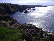
It is a wild and rugged landscape with large tracts of blanket bog, tiny isolated villages, white sandy beaches and towering cliffs of Benwee Head which, for thousands of years has remained relatively unscathed by overdevelopment by successive generations of Kilcommon inhabitants.
Situated at the mouth of Broadhaven Bay, on its 21st century surface, Kilcommon is characterised by its scenery, huge towering cliffs and rugged sea stacks interspersed with miles of white sandy beaches, tranquil islands and vast tracts of blanket bog with its rare and fragile biodiversity.
Kilcommon parish comprises a very ancient landscape of schist and pale creamy psammite along with some two billion year old pre-Cambrian pink striped gneisses.
Boulders of snow white quartz which intruded into the bedrock from geological turmoil below, some 450 million years ago (Silurian period) are to be found in the western part of the parish.
In recent times the growth of blanket bog, conifer forestry plantations and the absence of roads through the area, has made townlands such as Bunalty, Barrooskey, Baralty, Srahnaplaigh and Muingnabo difficult to access except by the most intrepid of explorers.
Since around the turn of the 21st century, Kilcommon parish has been affected by Corrib gas project, under the ownership of Royal Dutch Shell.
[19][20] Kilcommon Erris has a number of natural alternative energy resources due to its location on the Atlantic Ocean which brings almost constant winds from the sea.
[22] Tidal power, hydroelectric schemes, and wind farms are amongst the other alternative energy generation opportunities for which the area has potential.