Kinzie Street railroad bridge
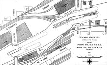
The Chicago and North Western Railway originally planned for two bridges side-by-side that could carry four railroad tracks into the Wells Street Station.
[9] However, by the time that the first bridge opened on September 19, 1908 an alternative scheme was already underway that led to the closure of Wells Street Station and its replacement with a new terminal on the west bank of the river.
[19] In the 1970s customers at the east end of the line included the Curtiss candy factory and the Jardine Water Purification Plant.
[4] Service to the Tribune Tower also ended in the 1980s,[4] and by the 1990s traffic along the remaining section of the spur served only one customer, the Chicago Sun-Times, with only one train per day.
[20] The newspaper moved their printing plant out of downtown Chicago in early 2001 leaving no traffic across the bridge and it has since been permanently raised in the open position.
[22] Tests were conducted in 1953 to see if the spur could be used as a part of a commuter line with stops at Merchandise Mart, State Street, and Michigan Avenue, but the plan was dropped in 1954 for financial reasons.
[4] In the 1970s architect Harry Weese suggested a light rail line along the spur to connect Chicago's downtown stations with the River North neighborhoods.
[4] In 2008 the City of Chicago Department of Transportation commissioned an alternatives analysis to look at a proposal to create a transit link from Union Station and the Ogilvie Transportation Center to Michigan Avenue using the Union Pacific train tunnel running under the Apparel Center, the Merchandise Mart and other buildings east toward North Michigan Avenue.
The proposed Carroll Avenue Transitway would include the retrofitting of Kinzie Street railroad bridge to carry buses or trams.