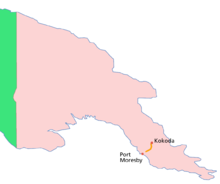
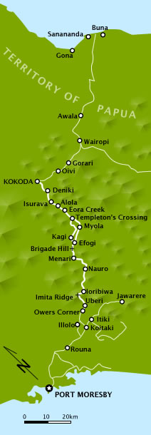
Kokoda Track
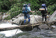
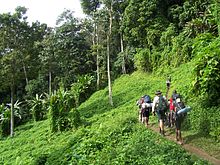
Hot, humid days with intensely cold nights, torrential rainfall and the risk of endemic tropical diseases such as malaria make it a challenging trek.
Between July 1942 and November 1942, a series of battles, afterwards called the Kokoda Track campaign, was fought between the Japanese and Australian forces.
This action was memorialised in the newsreel documentary Kokoda Front Line!, filmed by cameraman Damien Parer, which won Australia's first Academy Award for its director Ken G. Hall in 1942.
In 1964, Angus Henry, the art teacher at Sogeri High School, with two of his students, John Kadiba and Misty Baloiloi, set a new record which was to stand until after the millennium by completing the journey in three and a quarter days without guides, carriers or any signposts or bridges.
In 2006, the Owen Stanley Ranges and Kokoda Track was included on the Tentative List for World Heritage along with three other sites from PNG.
[8][11] In response, the Kokoda Track Authority announced that from the beginning of 2010, tour operators would require a commercial licence.
[citation needed] In August 2009, a group of trekkers were killed when their light plane, Airlines PNG Flight 4684, crashed en route to Kokoda Station.
[12] As a result, the Australian Government committed $1.8 million to improve the safety of airstrips at Kokoda, Menari, Kagi, Melei, Efogi, and Naduri, villages located along the track.
[14] In November 2009, Australian paralympian Kurt Fearnley (born without the lower section of his spine[15]) completed the track, crawling north to south, in 11 days.
A multiple paralympic gold medalist (T54 Marathon in Athens and Beijing), he used customized shin pads and wrist guards.
His journey was to raise awareness of men's health issues and was inspired by the story of Corporal John Metson, who crawled the track for three weeks, refusing the assistance of a stretcher on the grounds it would burden his comrades.
The earliest mention of the route in an Australian newspaper may be in The Argus on Wednesday 29 July 1942 in a map when it refers to "the Buna Kokoda-Moresby track".
He states that "Kokoda Trail" became common because of its use in Australian newspapers during the war, the first known instance being in Sydney's Daily Mirror on 27 October 1942.
The main villages passed through (from Owers' Corner) are Naoro, Menari, Efogi Creek 1 & 2, Kagi or Naduri (if shortcut is taken), Alolo, Isurava, Hoi, Kovolo.
Villagers are increasingly taking part in the commercial opportunities created by the growing number of tourists; in October 2006, some were known to be selling cans of soft drink and beer at double the price payable in Port Moresby.
The race record was again broken by Buka in the 2007 event when he completed the track in 17 hours 20 minutes on 26 August 2007, running in the reverse direction from Kokoda to Owers' Corner.
[29] The 2007 event also featured runners running from Owers' Corner to Kokoda and a winning time of 19 hours 9 minutes was set in this direction by Tom Hango.