Kontoskalion
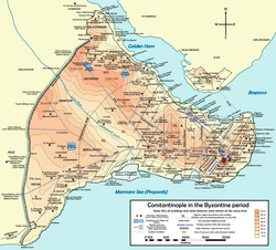
[1] The harbour lay in an inlet – still recognizable today in the flat landscape profile – of the Marmara Sea, in the third region of the city, at the southwest end of the valley of the Hippodrome.
The area of the harbour complex covers part of today's Mahalleler of Kadırga Limanı and Kumkapi in the Fatih district (the walled city) of Istanbul.
[3] On the other hand, the building of a harbour on the south shore was necessary to supply the western and southern regions of the city, too far from the Golden Horn.
[2] During his reign, Emperor Theophilos (r. 829–842) had an arsenal built near the harbour, in proximity of the Porta Leonis (the Ottoman Çatladı Kapı); it comprised a shipyard and armories.
[1] According to the Patria, this denomination is a patronymic referring to a certain Agallianos, a Byzantine tourmarches (senior army officer) nicknamed Kontoskeles because of his short legs,[5] but the German scholar Albrecht Berger rejects this as a mistake by the Patria authors, due to the different etymology of the two words: "Kontoskalion" means "short step or wharf".
[4] However, the beginning of the construction in 1515 of a new arsenal on the Golden Horn, the Tersâne-i Âmire, protected from the storms provoked by the southwest wind, and the enormous growth of the Ottoman navy, caused the decay of the Kadırga Limanı.
[9] The end of the port was accelerated by the erection of the Nuruosmaniye Mosque, started in 1748, since the excavated earth was partly thrown in the harbour.