Kottayam district
The headquarters of two religious communities in Kerala are also in the Kottayam District: Nair Service Society and the Indian Orthodox Church.
The name Kottayam is a combination of the words "kotta" and "akam" in the local language of Malayalam, meaning "interior of a fort".
[citation needed] A substantial portion of Kottayam district may have been under the Arabian Sea during prehistoric times.
[6] Early members of the Chera dynasty (first few centuries of the Common Era) had their original headquarters in a region called Kuzhamur at Kuttanad in the ancient Tamilakam and were sometimes known as the Kuttuvans.
[6] The province Kuttanad of the ancient kingdom of Keralaputras included the modern-day districts of Kottayam, Ernakulam, Idukki, and parts of Alappuzha, which can be defined as the region between the rivers Periyar and Pamba.
[6] It was during the reign of Uthiyan Cheralathan (105–130 CE) that the Chera dynasty began to expand towards the northern and the eastern regions of Kuttanad by conquering the provinces of Kudanadu and Kongu Nadu.
[6] Afterwards the dynasty got split into three branches and fixed their capitals at Muziris, Tyndis, and Caroura, respectively, as seen in the ancient Greco-Roman travelogues as well as the Old Tamil literary works of the Sangam period.
[6] This era marked the migration of Nambudiri Brahmins into the district, which later led to a transformation in the social structure of the region after the 10th century CE.
Sri Mulavasam was a prominent centre of Buddhism in the Indian peninsula until the early medieval period, prior to the Chera-Chola wars of the 11th century CE.
[6] Unnuneeli Sandesam, a work which belongs to the Malayalam literature written during early decades of the 14th century CE, contains a short geographical and political description of the regions and the medieval feudal states that lied between Kaduthuruthy and Thiruvananthapuram.
[6] The area included in the modern-day district of Kottayam was part of three Nadus (provinces) during the period of the Chera Perumals of Mahodayapuram (800–1102 CE) for nearly three centuries.
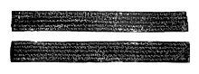
[10] The inscription is engraved on a single copper plate (with five lines on both sides) in an early form of the Old Malayalam language in Vatteluttu script with some Grantha characters.
[8] The record is dated to the twelfth regnal year of Chera Perumal king Rama Rajasekhara (882/83 CE).
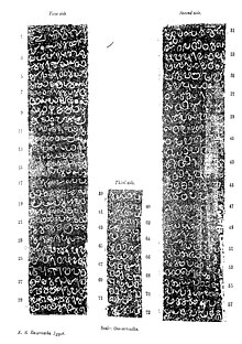
[10] Inscriptions related to Rama Kulasekhara (1089–1123 CE) of Chera Perumal dynasty can be found at Perunna near Changanassery.
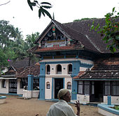
[6] Thazhathangady is one of the places in Kerala where a church, a mosque, and a Hindu temple co-exist together, which points out the religious harmony that existed under the Thekkumkur Rajas.
[6] Vadakkumkur was the northern branch of the erstwhile province of Vempolinadu which attained political autonomy in 1102 CE after the collapse of the Chera Perumals of Mahodayapuram.
[6] Vadakkumkur Raja was also a part of the combined military alliance formed by the kingdoms of Odanad (Kayamkulam), Thekkumkur, and Cochin against the expansion of Travancore into the northern territories.
[6] As a result, Anizham Thirunal Marthanda Varma, the architect of the modern Travancore, attacked and annexed Vadakkumkur in 1750.
[6] Upon the failure in the battle, Manavikrama appointed his brother Maravarman Sreevallabha as the monarch of the Pandya dynasty and left Madurai with his family and some of his trusted servants.
[6] Manavikrama purchased a vast tract of land bordering the Pandyan territories, from the ruler of Thekkumkur which comprised the Meenachil taluk the regions of Poonjar, Erattupeta, Pala, Patthanamthitta, Thodupuzha, etc.
along with the High Range region of modern-day Idukki district in 1160 CE, which originally belonged to the Thekkumkur Rajas.
The Kannan Devan Hills on the High Range region were given on lease on 11 July 1877 by the ruler of the Poonjar dynasty to John Daniel Munroe from London and for tea plantations.
[citation needed] Entire portion of the modern-day district of Kottayam became part of the erstwhile British princely state of Travancore by 1750 CE.
[6] Due to its remarkable progress in the fields of literacy, education, and printing, many early newspapers and magazines in Malayalam such as Deepika (1887) and Malayala Manorama (1888) were established in Kottayam.
[6] The goal of the movement was to seek more representation for Malayalis in the Travancore civil service irrespective of their caste and religion.
Pre-monsoon rains from March to May are accompanied by thunder and lightning; the highest rainfall during this period in Kerala is received in Kottayam.
Kottayam is linked by major roads and rail to other prominent cities in Kerala, and also by waterways allowing for waterborne travel.
[34] The major towns of the district include: Kottayam has a mountainous terrain as well as low-lying areas very close to sea level.
[citation needed]Aside from two public sector companies, Hindustan Newsprint at Velloor and Travancore Cements at Nattakom, industries in the district consist mostly of small and medium-size operations.
Kottayam, Thiruvalla, and Chengannur are the railway stations for pilgrims heading to the Hindu holy site of Sabarimala.