Kyrkbron, Umeå
Kyrkbron is a bridge in Umeå that takes Östra Kyrkogatan over Ume River to Teg on the south side.
During the construction an unknown burial ground was encountered (an older part of the cemetery), leading to archaeological excavations.
[7] Tegs municipal society then requested a report regarding the possibility of a bridge in the extension of Östra Kyrkogatan.
This led the provincial government to change their minds and it was decided that the bridge should be built at the extension of Västra Esplanaden.
In the land use plan an area was allocated for a bridge at the church and a highway from Tegsbron through central Teg.
[4] The land use plan, with the bridge situated next to the church, was created by Västerbottenskommunernas Arkitekt- och Byggnadskontor (VAB), with Åke Lundberg as the chief architect.
However, Åke Lundberg, who became the county architect in 1964, suggested that Orrje & Co's eastern alternative should be used as he argued that the technical and economic advantages of the placement next to the church did not outweigh the infringing of the aesthetic and historical values.
The memorandum emphasized that the bridge should be parallel to Tegsbron, to fit into the orthogonal and regular structure of the land use in the city.
Drätselkammaren, responsible for the city's economy, agreed with the Public Works Department's line, and argued that the placement next to the church took precedence over other options.
[18] In August 1966, Orrje & Co's report "Förslag till ny bro över Ume älv i sträckning Idrottsvägen-Östra Kyrkogatan" ("Proposal for a new bridge over the Ume River in the direction Idrottsvägen-Östra Kyrkogatan") that showed the traffic engineering principles that should form the basis of Kyrkbron.
The land use plan was revised according to Orrje & Co's report, and the projection of the bridge was done in collaboration with the Swedish Road Administration.
The County Administrative Board objected to the city's land use plan in 1969 and wanted an investigation into a more eastern location for the bridge.
This was followed by a heated debate that lasted six hours before the city council decided to allocate funding for the bridge.
[4] In June 1971 the county architect Åke Lundberg once again brought up the placement of the bridge during an information session on municipal issues in Holmsund.
The demonstration was initiated because a reader poll in the newspaper Västerbottens-Kuriren the previous day had shown that 84 percent were against the construction of Kyrkbron.
The motion was rejected on the ground that it would be more costly for the municipality to rework the city's land use plan and cancel existing contracts than to continue the construction.
[30] The discovery made the county custodian of antiquities Sune Zachrisson and the Swedish National Heritage Board to put the construction of the bridge to a halt as the area would undergo archaeological excavations.
[30] During the construction of the bridge a few technical novelties were used such as a desktop computer when surveying and the distance was measured with a laser.
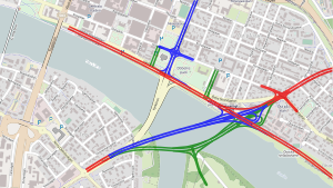
[4][32] In connection with the construction of the bridge an extensive rerouting of the traffic in central Umeå and Teg was also carried out.
[35] Because of Kolbäcksbron, a reduced amount of traffic in the center and the transformation of Strandgatan from a transit route to a city street.