Louisiana Highway 22
Near the town of Springfield, the highway enters the thick pine forest characterizing the north shore of Lake Pontchartrain and intersects the concurrent I-55/US 51 in Ponchatoula.
In its early years, LA 22 extended across the Mississippi River by ferry to Donaldsonville prior to the existence of the nearby Sunshine Bridge.
The route heads northeast from the small Ascension Parish community of Darrow as an undivided two-lane highway, traveling through Hillaryville across the Canadian National Railway (CN) line and to the rear of Houmas House Plantation and Gardens.
Shortly afterward, LA 22 widens to a divided four-lane highway and passes through a diamond interchange with I-10 at exit 182, connecting with Baton Rouge and New Orleans.
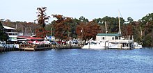
The highway crosses a bridge over the wide Amite River Diversion Canal, which is lined by boat houses and fishing camps.
The route then proceeds across a higher and longer bridge spanning the Tickfaw River, allowing a splendid view of the surrounding cypress swamp.
For the remainder of its journey, LA 22 travels about two to three miles (3.2 to 4.8 km) to the south of I-12, the main east–west highway through the Florida Parishes on the north shore of Lake Pontchartrain.
On the outskirts of town, LA 22 widens to four lanes as it passes through a full cloverleaf interchange with the concurrent I-55/US 51, connecting with the larger nearby city of Hammond, as well as New Orleans.
East of Ponchatoula, LA 22 resumes as a two-lane highway through the thick pine woods for 10 miles (16 km) before crossing into St. Tammany Parish at Bedico.
[2][6][8] A divided four-lane thoroughfare known as West Causeway Approach branches off of LA 22 and provides access to several area schools and more residential subdivisions.
More than half of the route is classified as a rural major collector, including two large portions from Acy to Springfield and from Ponchatoula to Madisonville.
[19][b] When US 190 was returned to its regular route through Covington the following year, LA 22 was extended to its current terminus at Chinchuba, an area now within the Mandeville city limits.
[19][20] The actual terminus was a simple Y-intersection at what is now LA 3228 (Asbury Drive) until the present diamond interchange aligned with North Causeway Boulevard was constructed in 1981.
[2] The only other significant realignment to LA 22 occurred in 1990 when Sorrento's Main Street was bypassed by a new four-lane alignment (John Leblanc Boulevard) that facilitated traffic between I-10 and US 61.
[28][29] La DOTD is currently engaged in a program that aims to transfer about 5,000 miles (8,000 km) of state-owned roadways to local governments over the next several years.
[30] Under this plan of "right-sizing" the state highway system, two portions of LA 22 are proposed for deletion as they no longer meet a significant interurban travel function.