La Cañada Flintridge, California
Flintridge comprises the southern part of the city, covering the northern flank of the San Rafael Hills, but more generally including most areas south of Foothill Blvd.
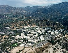
La Cañada Flintridge varies in elevation from about 970 feet (300 m) just below Devil's Gate Dam in the Arroyo Seco to about 2,400 feet (730 m) at the highest neighborhood, along the mountain front east of Pickens Canyon, at the upper end of Ocean View Blvd.
[13] In January 2025, virtually the entire city was evacuated in response to the Eaton Fire, which destroyed many homes in the neighboring community of Altadena.
[14] The climate of La Cañada Flintridge is typical of a Southern California inland valley, with mild winters and hot summers.
Consequently, summers are generally hotter and winters often cooler than in coastal parts of metropolitan Los Angeles, if winds are calm or blowing gently offshore.
Summer and early fall temperatures are substantially cooler if the prevailing wind is persistently onshore.
According to the 2010 United States Census, La Cañada Flintridge had a median household income of $136,818, with 3.2% of the population living below the federal poverty line.
[41] La Cañada Flintridge is governed by its city council, which has five members, each elected to overlapping four-year terms.
It also serves as the governing board for the public improvement corporation, the redevelopment agency, the LCF Local Financing Authority, and Sanitation Districts No.
[48] In the California State Assembly, La Cañada Flintridge is located in the 41st district, and is represented by Chris Holden.
[citation needed] Several private schools that are not part of the LCUSD are located within La Cañada.
The school left the city when its current campus in Lake View Terrace, Los Angeles opened in 2003.
However, in April 2020, the Los Angeles Times announced it would be shutting down some of its local papers, including the La Cañada Valley Sun due to continuing financial issues that were worsened by the COVID-19 pandemic.
Annual landscaping inspections and "stringent fire-safe building codes" were put in place to mitigate the risk of wildfires, like the 2009 Station Fire.
[13][58] Foothill Boulevard is the main artery of La Cañada Flintridge, running through the center of the city.
[59] The strip of land north and south of Foothill represents the major commercial zone of the city.
[61] The building of the freeway required the acquisition and demolition of over 400 homes,[62] and the relocation of La Canada Elementary, the post office, and some businesses.
It begins at the intersection with Foothill Boulevard and follows a two-mile, 5% grade before entering the San Gabriel Mountains.
On September 5, 2008, a big rig carrying 78,000 pounds of onions lost its brakes on the Angeles Crest Highway.
James Bines, 43, of Florida, and his passenger, Willy Robinson, had been hauling a full load of onions through the high desert area in the 18-wheeler.
A car carrier transporting six cars southbound on the Angeles Crest Highway lost its brakes and, despite three runaway vehicle escape medians in the center islands, caused multiple vehicle accidents that resulted in two fatalities and 12 injuries, three of them critical.
Angel Jorge Posca, 58, and his 12-year-old daughter Angelina, both of Palmdale, had just exited the eastbound Foothill Freeway at the Angeles Crest Highway in their red Ford Escort and were starting to turn north on the highway to return to Palmdale when the semi-truck struck their vehicle.
[67] A bill that bans heavy trucks with three or more axles from driving on the Angeles Crest Highway was signed into law by Gov.
[68] In 2021, two crashes occurred over the same weekend at the intersection, with one damaging Hill Street Cafe and the other largely destroying a boutique, resulting in its permanent closure.
[69] On October 9, 2024, a Toyota Prius traveling southbound on Angeles Crest Highway crashed into six cars parked at the side entrance of the restaurant.