Santa Monica Mountains
The range extends approximately 40 miles (64 km) east-west from the Hollywood Hills in Los Angeles to Point Mugu in Ventura County.
The western mountains, separating the Conejo Valley from Malibu, suddenly end at Mugu Peak[2] as the rugged, nearly impassible shoreline gives way to tidal lagoons and coastal sand dunes of the alluvial Oxnard Plain.
The mountain range contributed to the isolation of this vast coastal plain before regular transportation routes reached western Ventura County.
The Santa Monica Mountains have more than 1,000 archeology sites of significance, primarily from the Californian Native American cultures of the Tongva and Chumash people.
Volcanic intrusions have been exposed, including the poorly named andesitic[6] "Sandstone Peak", which is the highest point in the range at 3,111 feet (948 m).
The Santa Monica Mountains have dry summers with frequent coastal fog on the ocean (south) side of the range and rainy, cooler winters.
In the Santa Monica Mountains, when the fuels, seasonal drought, wind, and terrain combine with an ignition, a major wildfire occurs.
The Santa Monica Mountains face pressure from local populations as a desirable residential area, and in the parks as a recreational retreat and wild place that's increasingly rare in urban Los Angeles.
[19] The Satwiwa Native American Indian Culture Center in Newbury Park, California is located within the Santa Monica Mountains National Recreation Area.
The Rim of the Valley project also has the goal to protect flora and fauna habitats and wildlife corridors between the Santa Monica Mountains and the inland ranges.
Common mammals in the range include mule deer, coyotes, bobcats, striped skunks, raccoons, several native bat species, brush rabbits, and many rodents including California voles, western gray squirrels, dusky-footed and desert woodrats, western harvest and California pocket mice, Botta's pocket gophers, and pacific kangaroo rats.
[26][27][28][29] The primary cause of the decline is due to a combination of traffic-related mortality,[30][31] anti-coagulants ingested from human poisoned prey, and attacks by other, more dominant mountain lions.
[33] The National Park Service has recorded a dozen mountain lions struck and killed by motorists on this section of freeway since 2002 when they began a study.
[34] Mountain lions approach this particular area and turn back without attempting the hazardous crossing of the freeway as shown by GPS tracking collars fitted to them by the researchers.
[37] It would allow young mountain lions, born in the Santa Monicas, a chance to find a new territory before possibly being killed by one of the more dominant, older males.
[47][25] Native fish found in the Santa Monica Mountains include tidewater gobies, arroyo chub, and pacific lamprey.
This species is endemic to Ventura County and is found only on one edge of the Santa Monica Mountains, where it occurs in coastal sage scrub habitat.
Many invasive weeds have colonized the mountain habitats which can bring about significant changes in the ecosystems by altering the native plant communities and the processes that support them.
These non-native plants include annual Mediterranean grasses, Spanish broom (Genista juncea), and yellow starthistle (Centaurea solstitialis).
Mulholland Drive runs much of the length of the Santa Monica Mountains, from Cahuenga Pass to Woodland Hills, although it is not open to motor vehicles west of Encino.
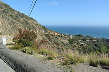
The city of Malibu runs between the coast and the leading mountain ridge, from Topanga Canyon in the east to Leo Carrillo State Park in the west.