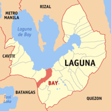
Laguna de Bay
The lake is shaped like a crow's foot, with two peninsulas jutting out from the northern shore and filling the large volcanic Laguna Caldera.
Environmental issues such as water quality problems created by population pressure and industrialization, invasive species and overfishing are of concern for the lake, hurting its economic importance to the country.
[3] Alternate spellings of the town's name include "Bae" or "Ba-i", and in the early colonial times, "Bayi" or "Vahi".
[6] In the pre-Hispanic era, the lake was known as "Puliran Kasumuran" (Laguna Copperplate Inscription, c. 900 AD), and later by "Pulilan" (Vocabulario de la lengua tagala, 1613.
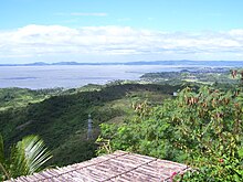
[8] It is considered to be the third largest inland body of water in Southeast Asia after Tonle Sap in Cambodia and Lake Toba in Sumatra, Indonesia.
The lake is a multipurpose resource,[17] used for fishery, transportation, irrigation of agricultural lands, power generation, and as a reservoir for regional flood management, among other things.
[18][19] Because of its importance in the development of the Laguna de Bay Region, unlike other lakes in the country, its water quality and general condition are closely monitored.
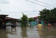
[25] Government data showed that about 60% of the estimated 8.4 million people residing in the Laguna de Bay Region discharge their solid and liquid wastes indirectly to the lake through its tributaries.
In a recent sensitivity waste load model ran by the Laguna Lake Development Authority's (LLDA) Integrated Water Resources Management (IWRM) division, it revealed that 70% of biochemical oxygen demand (BOD) loadings came from households, 19% from industries, and 11% came from land run-off or erosion (LLDA, 2005).
This paved the way for massive and intensified use of chemical based fertilizers and pesticides whose residues eventually find their way to the lake basin.
To complement the floodway, the Napindan Hydraulic Control System (NHCS) was built in 1983 at the confluence of the Marikina River and the Napindan Channel of the Pasig River to regulate the tidal flow of saline water between Manila Bay and the lake, and to prevent the intrusion of polluted water into the lake.
Over 40,000 households are situated along the floodway's banks[36] and these shoreline slums have reduced its effective width to 220 meters (720 ft).
The project will involve the construction of a 47-kilometer-long (29 mi), six-lane dike including bridges, pumping stations and ancillary flood gates.
[43] The project will also involve the reclamation of 700 hectares (1,700 acres) west of and abutting the expressway dike, separated from the shoreline by a 100-to-150-meter (330 to 490 ft) channel in Taguig and Muntinlupa.
The highway project has a total length of about 37.4 kilometers (km) expressway from Lower Bicutan in NCR to Calamba in Laguna Province, consisting of (i) 11.7 km long viaduct from Lower Bicutan to Tunasan; and (ii) 25.7km long combination of shoreline viaduct and embankment from Tunasan to Calamba.
[48] The Manila Water began laying down in 2021 two high density polyethylene (HDPE) underground and 21 km submarine pipes from Binangonan, Cardona, Morong, and Pililla to expand their services under the East Bay Phase 1 Project.
[49][50] East Bay Phase 2 Project will involve construction of a water treatment plant (WTP) at Bgy.
The WTP once completed will produce 200 MLD for the Metro Manila East Zone through the submarine pipeline under the lake.
[53] Originally only created as a quasi-government agency with regulatory and proprietary functions, its charter was strengthened by Presidential Decree (PD) 817 in 1975 and by Executive Order (EO) 927 in 1983 to include environmental protection and jurisdiction over the surface waters of the lake basin.
[57] Laguna de Bay has had a significant impact on the cultures of the communities that grew up around its shores, ranging from folk medicine to architecture.