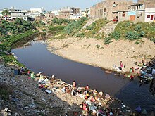
Lai Nullah
Every monsoon season the stream floods after being fed by its catchment basin in the Margalla Hills bordering Islamabad, Pakistan.
[1] A record level of 620 mm of rainfall fell in Islamabad, Pakistan one in just 10 hours brought in its wake huge urban storm flooding in the famous Lai Nullah flowing through the twin cities on 23 July 2001.,[2][3] Islamabad and Rawalpindi are situated along the Margallah hills.
Densely populated low-lying areas along Lai Nullah faced flood like situation causing massive destruction of property and life.
REF RDA DOC The climate of the Lai Nullah Basin area is classified as “Subtropical Triple Season Moderate Climate Zone”, which is characterized by single rainfall season from July to September and its moderating influence on temperature.
Below Kattarian Bridge, in the jurisdiction area of Rawalpindi, the main stream meets other three major tributaries; namely (i) Nikki Lai, (ii) Pir Wadhai Kas and (iii) Dhok Ratta Nullah one after another, then flows down through the center of Rawalpindi City and finally pours into Soan River.
In the upper reaches, Lai Nullah cuts through the surficial deposits, which generally consists of Potwar loessic silt.
On July 23, 2001, an unprecedented rainfall occurred over Islamabad Rawalpindi resulting in 620 mm of rain in a span of about 10 hours.
The flood had caused the worst damage in the basin including death of 74 people and the complete or partial destruction of about 3,000 houses.
The intensity and amount of rainfall caused the water level of Lai Nullah and its tributaries to rise remarkably and flooding Rawalpindi (where the damages were several times larger than in Islamabad).