Lake Agassiz
[4] During the last glacial maximum, northern North America was covered by an ice sheet, which alternately advanced and retreated with variations in the climate.
This continental ice sheet formed during the period now known as the Wisconsin glaciation, and covered much of central North America between 30,000 and 10,000 years ago.
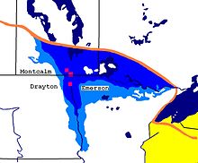
[6] Around 13,000 years ago, this lake came to cover much of what are now southeastern Manitoba, northwestern Ontario, northern Minnesota, eastern North Dakota, and Saskatchewan.
[2][10][11][12] The ice returned to the south for a time, but as it again retreated north of the present Canada–United States border around 10,000 years ago, Lake Agassiz refilled.
This final drainage of Lake Agassiz has been associated with an estimated 0.8 to 2.8 m (2.6 to 9.2 ft) rise in global sea levels.
[13] Lake Agassiz's major drainage reorganization events were of such magnitudes that they significantly impacted climate, sea level, and possibly early human civilization.
[17] The lowest point between the drainage of Hudson Bay and the Gulf of Mexico is in the Traverse Gap between the U.S. states of Minnesota and South Dakota.
The outflow from the melting glaciers filled Lake Agassiz and then drained through the gap to the Gulf of Mexico.
This mass of moving water eroded a valley 2–5 kilometres (1.2–3.1 mi) wide and from 100 to 125 feet (30 to 38 m) deep.
[1] As the ice sheet melted northward, an early Lake Agassiz covered southern Manitoba, the Minnesota and Ontario boundary country, and along the Red River south of Fargo, North Dakota.
During the Lockhart Phase the lake is estimated to have been 231 metres (758 ft) deep, with greater depths near the glacier.
[1] As the ice sheet melted northward, Lake Agassiz found a lower outlet through the Kaministikwia route along the modern Minnesota–Ontario border.
Drainage from Lake Agassiz continued to flow southward out of the ancient Minnesota and Mississippi River systems into the Gulf of Mexico.
Dating of the glacial moraines shows that the Clearwater and Athabasca River system and Lake Nipigon and Minong basin were still ice-covered.
The lower lake level ended the southern outlet through the ancestral Minnesota and Mississippi River systems.
This was due to isostatic rebound of the northern shorelines combined with the opening of the North Bay outlet of the Lake Huron basin.
[1] The shifting ice sheet created fluctuating drainage channels into the Lake Nipigon and Superior basins.
Isostatic rebound of glaciated lands that were south of the ice sheet created a long linear lake from the Saskatchewan–Manitoba border to Quebec.
These may be linked with the Ojibway Phase of Lake Agassiz and may indicate large amounts of drainage from the Ottawa River valley and the Tyrrell Sea (ancestral Hudson Bay).
The ice sheet continued its northward retreat to Baffin Island, leaving the North American mainland around 5,000 YBP.
The Herman Beach is the highest shoreline and can be traced from the historic outlet at Lake Traverse on the border of Minnesota and South Dakota.
[29] The Herman Beach displays numerous deltas from the major rivers that entered Lake Agassiz.