Glacial River Warren
Agassiz was an enormous body of water, up to 600–700 ft (180–210 m) deep, and at various times covering areas totaling over 110,000 sq mi (280,000 km2).
[3] Blocked by an ice sheet to the north, the lake water rose until about 13,500 BP calibrated (11,700 14C uncalibrated) years ago when it overtopped the Big Stone Moraine, a ridge of glacial drift left by the receding glacier, at the location of Browns Valley, Minnesota.
The lake's outflow was catastrophic,[4] and carved a gorge through the moraine 1 mi (1.6 km) wide and 130 ft (40 m) deep, which is now known as the Traverse Gap.
From its inception until final abandonment of Agassiz' southern outlet, this stream drained the meltwater of that lake to the Mississippi valley.
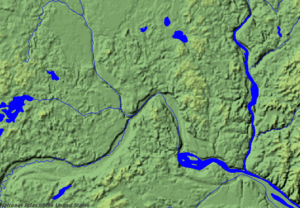
[7] While active this turbulent stream cut and eroded a bed up to 5 mi (8.0 km) wide and 250 ft (76 m) deep,[8] leaving a valley which starts at Traverse Gap near Browns Valley, Minnesota, goes southeast to Mankato, then turns northeast to the Twin Cities.
[10] By about 9400 BP, the ice sheet finally retreated sufficiently far to the north that Lake Agassiz permanently took another outlet and receded below the level of Traverse Gap.