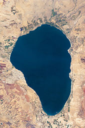
Sea of Galilee
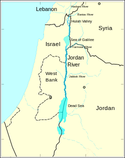
[5] The lake is fed partly by underground springs, but its main source is the Jordan River, which flows through it from north to south with the outflow controlled by the Degania Dam.
A persistent, though likely erroneous, popular etymology presumes that the name Kinneret may originate from the Hebrew word kinnor ("harp" or "lyre"), because of the shape of the lake.
[10] The scholarly consensus, however, is that the origin of the name is derived from the important Bronze and Iron Age city of Kinneret, excavated at Tell el-'Oreimeh.
Nahal Ein Gev, located about 3 km (1.9 mi) east of the lake, contains a village from the late Natufian period.
The site is considered one of the first permanent human settlements in the world from a time predating the Neolithic Revolution.
[18] According to Sugimoto (2015), the Iron Age IB (1150–1000 BCE) cities in the northeastern region of the Sea of Galilee likely reflect the activities of the Kingdom of Geshur, mentioned in the Bible.
The Greeks, Hasmoneans, and Romans founded flourishing towns and settlements on the lake including Hippos and Tiberias.
Contemporary Roman–Jewish historian Flavius Josephus was so impressed by the area that he wrote, "One may call this place the ambition of Nature"; he also reports a thriving fishing industry at this time, with 230 boats regularly working in the lake.
In those days, there was a continuous ribbon development of settlements and villages around the lake and plenty of trade and ferrying by boat.
One of Jesus' famous teaching episodes, the Sermon on the Mount, is supposed to have been given on a hill overlooking the Kinneret.
Many of his miracles are also said to have occurred here including his walking on water, calming the storm, the disciples and the miraculous catch of fish, and his feeding five thousand people (in Tabgha).
Tiberias did see a significant revival of its Jewish community in the 16th century but had gradually declined until the city was destroyed in 1660.
In the early 18th century, Tiberias was rebuilt by Zahir al-Umar, becoming the center of his rule over Galilee, and seeing also a revival of its Jewish community.
The Zionist movement pressured the French and British to assign as many water sources as possible to Mandatory Palestine during the demarcating negotiations.
The High Commissioner of Palestine, Herbert Samuel, had sought full control of the Sea of Galilee.
[25] The negotiations led to the inclusion into the Palestine territory of the whole Sea of Galilee, both sides of the River Jordan, Lake Hula, Dan spring, and part of the Yarmouk.
The British and French Agreement provided that existing rights over the use of the waters of the River Jordan by the inhabitants of Syria would be maintained; the government of Syria would have the right to erect a new pier at Semakh on Lake Tiberias or jointly use the existing pier; persons or goods passing between the landing-stage on the Lake of Tiberias and Semakh would not be subject to customs regulations, and the Syrian government would have access to the said landing-stage; the inhabitants of Syria and Lebanon would have the same fishing and navigation rights on Lakes Huleh, Tiberias and River Jordan, while the government of Palestine would be responsible for policing of lakes.
The agreement stated that the armistice line was "not to be interpreted as having any relation whatsoever to ultimate territorial arrangements."
As a result of horizontal shifts in the north–south direction and subsidence of the area, a lake was formed, with an asymmetrical bottom—steeper in the east and a gentler in the west.
During a routine sonar scan in 2003 (finding published in 2013),[33] archaeologists discovered an enormous conical stone structure.
The Sea of Galilee is at risk of becoming irreversibly salinized by the salt water springs under the lake, which are held in check by the weight of the freshwater on top of them.
[47] This project and Israel's attempt to block these efforts in 1965 were factors which played into regional tensions culminating in the 1967 Six-Day War.
[48] Under the terms of the Israel–Jordan peace treaty, Israel also supplies 50 million m3 (1.8 billion cu ft) of water annually from the lake to Jordan.
[49] In recent years the Israeli government has made extensive investments in water conservation, reclamation and desalination infrastructure in the country.
The Sea of Galilee is an attraction for Christian pilgrims who visit Israel to see the places where Jesus performed miracles according to the New Testament.
Alonzo Ketcham Parker, a 19th-century American traveler, called visiting the Sea of Galilee "a 'fifth gospel' which one read devoutly, his heart overflowing with quiet joy".
It includes a network of footpaths, roads and bicycle paths linking sites central to the lives of Jesus and his disciples.
[51] Another key attraction is the site where the Sea of Galilee's water flows into the Jordan River, to which thousands of pilgrims from all over the world come to be baptized every year.
[53] Other economic activities include fishing in the lake and agriculture, particularly bananas, dates, mangoes, grapes and olives in the fertile belt of land surrounding it.
[56] Local fishermen talk of four types of fish: "مشط musht" (tilapia); sardin (the Kinneret bleak, Mirogrex terraesanctae); "بني biny" or Jordan barbel, Luciobarbus longiceps (barb-like); and North African sharptooth catfish (Clarias gariepinus).