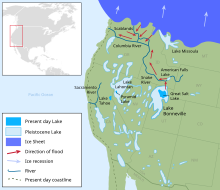
Lake Lahontan
The area of the former lake is a large portion of the Great Basin that borders the Sacramento River watershed to the west.
[1][2] At its peak approximately 12,700 years ago (during a period known as the Sehoo Highstand), the lake had a surface area of over 8,500 square miles (22,000 km2),[3] with its largest component centered at the location of the present Carson Sink.
[5] Climate change around the end of the Pleistocene epoch led to a gradual desiccation of ancient Lake Lahontan.
[citation needed] Recent computer simulations (using the DSSAM Model[6] and other techniques) indicate, if precipitation and evaporation rates within the watershed were maintained at their historical yearly maximum and minimum, respectively, and if diversions of the Truckee River ceased, the Ice Age extent of Lake Lahontan might return.
Archaeological evidence along the shore indicates the existence of the lake coincided roughly with the first appearance of humans in the region.