Lake Poopó
[2][3] Due to the lake's length and width (90 by 32 km; 56 by 20 mi), it made up the eastern half of Oruro, known as a mining region in southwest Bolivia.
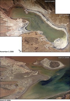
Since the lake lacked any major outlet and had a mean depth of less than 3 m (10 ft), the surface area differed greatly seasonally.
[10] Archaeological investigations conducted by the San Andrés University of La Paz, Bolivia, shows the influence of the Wankarani culture in the Poopó area.
Complex central urban areas, such as villages and towns, were developed that expanded into the Poopó basin during the Late Formative period, (200 BC – 200 AD), probably in conjunction with changing patterns of agriculture.
Herders and the life style of llama caravan merchants coexisted with more sedentary farmers in a harmonious system of exchange of goods and services.
Other investigators examining the following period, the Early Regional Developments (c. 300 – 900 AD), have concluded that the size of the inhabited areas increased.
At times of very high water levels, Poopó was connected to the salt desert Salar de Coipasa in the west.
In the northern end of Lake Poopó, dilution of the salinity occurred due to freshwater flow from the Desaguadero River.
[clarification needed] Geological sources of sodium chloride (NaCl), such as halite and feldspars, are present in the drainage area.
Studies have shown elevated concentrations of heavy metals in surface and ground waters of the Poopó basin.
There were only three fish species in the system: the native pupfish Orestias agassizii and catfish Trichomycterus rivulatus, and the introduced silverside Odontesthes bonariensis.
Most famous are the three species of flamingo (Andean, James's and Chilean), which mainly lived in the shallow lagoons in the northern and eastern parts of the lake.
[16][17] Additionally, many bird species native to Bolivia and internationally have been affected due to loss of food, and an annual migration area.