Lake Turkana
On-shore and off-shore winds can be extremely strong, as the lake warms and cools more slowly than the land.
Three rivers (the Omo, Turkwel and Kerio) flow into the lake, but lacking outflow, its only water loss is by evaporation.
After the independence of Kenya, the president, Mzee Jomo Kenyatta, renamed it in 1975 after the Turkana, the predominant tribe there.
The lake was originally named Lake Rudolf (in honour of Crown Prince Rudolf of Austria) by Count Sámuel Teleki de Szék and his second-in-command Lieutenant Ludwig Ritter Von Höhnel, a Hungarian and an Austrian, on 6 March 1888.
[9] At some unknown time, the lake acquired an alternative name as the Jade Sea from its turquoise colour seen approaching from a distance.
J. W. Gregory reported in The Geographical Journal of 1894 that it was called "Basso Narok", meaning "Black Lake" in the Samburu language.
The lake holds about 50 fish species, including 12 endemics: the cichlids Haplochromis macconneli, H. rudolfianus, H. turkanae and Hemichromis exsul, the barb Enteromius turkanae, the catfish Chrysichthys turkana, the robber tetras Brycinus ferox and B. minutus, the Rudolf lates Lates longispinis, the lampeyes Lacustricola jeanneli and Micropanchax rudolfianus, and the cyprinid Neobola stellae.
[11][13] During the early Holocene, the water level of the lake was higher, and it overflowed into the Nile River, allowing fish and crocodiles access.
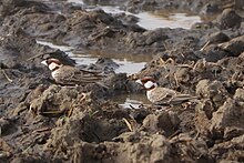
[14] The East African Rift System also serves as a flyway for migrating birds, bringing in hundreds more.
The lake formerly contained Africa's largest population of Nile crocodiles: 14,000, as estimated in a 1968 study by Alistair Graham.
[18] A rift is a weak place in the Earth's crust due to the separation of two tectonic plates, often accompanied by a graben, or trough, in which lake water can collect.
The basement rocks of the region have been dated by two analytical determinations to 522 and 510 million years ago (mya).
Short-term fluctuations in lake level combined with periodic volcanic ash spewings over the region have resulted in a fortuitous layering of the ground cover over the basal rocks.
[23] It is generally theorised that Turkana was part of the upper Nile system at that time, connecting to Lake Baringo at the southern end and the White Nile in the north, and that volcanic land adjustments severed the connection.
[27] The changing forest environment forced the early humans to adapt to a more open grassland that increased their exposure to threatening predators.
Volcanic ash and drier climates were ideal for preserving these human fossils but it also caused the lake to shrink or disappear at times.
In a dry riverbed, the Lomekwi 3 site recovered primitive hammers, anvils, and cutting tools.
However, the emergence of Acheulean technology no longer assumes that tool use was a distinguishing factor among Homo species as Australopithecus afarensis were also using simple tools prior to the appearance of the genus Homo, over 3.3 million years ago.
In 1984, the Turkana Boy, a nearly complete skeleton of a Homo ergaster juvenile, was discovered by Kamoya Kimeu.
More recently, Meave Leakey discovered a 3.5 million-year-old skull there, designated Kenyanthropus platyops ("the flat-faced man of Kenya").
This was mostly supplanted by animal-based agriculture by 5000 years ago, when the lake level was in a period of rapid fluctuation.
[36] People who live in the region today commonly practice mixed subsistence, switching between hunting, fishing and animal herding based on what is feasible in a given year.
[34] However, the construction of infrastructure like Christian missionary stations, energy extraction (wind, oil) and NGO aid distribution points have made the region more connected to and dependent on outside resources for subsistence.
The report offers a devastating look at a deeply flawed development process fueled by the special interests of global finance and African governments.
A hydrological study conducted for the African Development Bank in November 2010 concluded that the filling of the dam will reduce the lake's water level by two metres, if no irrigation will be undertaken.
[30] This could cause the brackish water to increase in salinity to where it may no longer be drinkable by the indigenous groups around the lake.
"[9] According to dam proponents, the impact on Lake Turkana will be limited to the temporary reduction in flows during the filling of the reservoir.
[31] With no outlet, Lake Turkana loses 2.3 meters of water every year to evaporation, and its level is sensitive to climatic and seasonal fluctuations.
[32] The director of Kenya's Water Services Regulatory Board, John Nyaoro, argued that the dam would have no negative impact on Lake Turkana.
[33] A Kenya Government report in 2021 estimated that the surface area of Lake Turkana had increased by 10% between 2010 and 2020.