Lake of the Woods
Lake of the Woods (French: Lac des Bois; Ojibwe: Pikwedina Sagainan [3], lit.
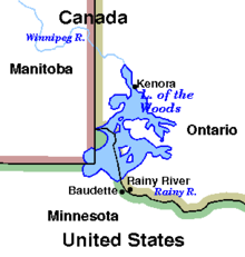
Its "northwesternmost point" served as a problematic landmark in treaties defining the international border.
He says it was called Lake Minitic (Cree: ministik; Ojibwe: minitig) or Des Bois.
The federal governments of Canada and the United States referred the matter to the International Joint Commission (IJC) in 1912.
In 1917 the IJC recommended the creation of control boards and the operating conditions they would apply to lake level management.
Following the IJC recommendations of 1917, discussions between the federal governments of Canada and the United States resulted in the 1925 Canada/USA Convention and Protocol regarding Lake of the Woods.
In cases where agreement could not be reached between Canadian and American members of the international board, the disputed matter would be referred to the IJC for the final decision.
It is connected to the mainland with a tiny neck of land at its southeast corner, but a canal (Turtle Portage 49°11′50″N 94°07′26″W / 49.1972528°N 94.1239568°W / 49.1972528; -94.1239568) was cut through at this point, effectively making the Aulneau an island.
Several parks are located in and on the lake, including: Minnesota's Zippel Bay State Park offers a wide variety of services including campsites, toilet facilities, a marina with access to the Zippel River, and a beach.
Minnesota and Ontario both offer state-sanctioned parks and campsites, which can be located through the respective governments.
Backcountry campers can locate a prospective campsite on Lake of the Woods by boat, landing and examine the site in person.