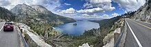
Lake Tahoe
The maximum legal limit to which the lake can be allowed to rise in order to store water is at 6,229.1 ft (1,898.6 m); a spillway at the dam controls overflow.
Lake Tahoe is the youngest of several extensional basins of the Walker Lane deformation zone that accommodates nearly 0.47 in (12 mm) per year of dextral shear between the Sierra Nevada-Great Valley Block and the North America plate.
[28] A massive collapse of the western edge of the basin that formed McKinney Bay around 50,000 years ago is thought to have generated a tsunami/seiche wave with a height approaching 330 ft (100 m).
Competition from introduced fish led cutthroat trout to be completely extirpated from the lake in the early 20th century until reintroduction efforts started in 2019.
[37][38] Each autumn, from late September through mid-October, mature sockeye salmon transform from silver-blue color to a fiery vermilion, and run up Taylor Creek, near South Lake Tahoe.
After spawning they die and their carcasses provide a feast for gatherings of mink (Neogale vison), bears (Ursus americanus), and bald eagles (Haliaeetus leucocephalus).
Lake Tahoe was the center and heart of Washoe Indian territory, including the upper valleys of the Walker, Carson and Truckee Rivers.
By the start of the American Civil War in 1861, former Governor Bigler, once a Free Soil Democrat, had become such an ardent Confederate sympathizer that Union advocates objected to the name.
The Sacramento Union jokingly suggested the name "Largo Bergler" for Bigler's widely perceived financial incompetency in his final term and contemporary Southern sympathies.
Europeans first impinged upon the Lake Tahoe basin with the 1858 discovery of the Comstock Lode, a silver deposit just 15 miles (24 km) to the east in Virginia City, Nevada.
[58] The first steamboat on Lake Tahoe was the 42-foot (13 m) paddle wheel tugboat Governor Blasdel towing log rafts to a sawmill on the south side of Glenbrook Bay from 1863 until her boiler exploded in 1877.
The centuries long dispute that erupted began with boundary discrepancies across many surveys within which were valuable mineral deposits; Nevada also had a wish that California would assent to cede its land east of the pacific crest as had been preauthorized by Congress in 1850.
Against initial instructions, Von Schmidt began his survey with the 1872 California-Nevada State Boundary Marker[64] which was six-tenths of a mile east of the Houghton-Ives line.
In a striking display of opportunism which ostensibly occurred because the boundary was still "officially" unsurveyed, settlers arrogated parts of California up to the irregular Sierra Crest tens of miles east of the boundary—defined over six years prior—in an attempt to create Nataqua Territory.
[67] Even after six surveys, conflict remained over which of them, if any, were legally binding in marking the boundary;[66] this was partially heard by the Supreme Court of the United States in 1980, where the doctrine of acquiescence was invoked.
Holding assumptions of the earth back-in-time, modern satellite assisted survey techniques can determine location and transform them onto old ellipsoids to within a centimeter.
[66] There is an official federal[65] obelisk-shaped monument marking the oblique California border, which is now surrounded by Edgewood Tahoe golf resort that is claimed and taxed by Nevada.
[75] Public capacity to navigate across any land formerly inundated by the waterway is not extinguished by the lowering of the lake level; this federal easement is maintained under United States law.
[79] Because small fluctuations in the height of the shoreline can result in substantive temporal immersions by the lake surface, the irreversible public easement slowly grows larger in size.
[127] Recent research has shown that the urban uplands also provide the largest opportunity to reduce fine sediment particle and phosphorus contributions to the lake.
Because of the sensitivity of Truckee River water quality (involving two protected species, the cui-ui[134] sucker fish and the Lahontan cutthroat trout), this drainage basin has been studied extensively.
The primary investigations were stimulated by the U.S. Environmental Protection Agency, which funded the development of the DSSAM model to analyze water quality below Lake Tahoe.
Currently, the Tahoe Regional Planning Agency is regulating construction along the shoreline[141] (and has won two Federal Supreme Court battles over recent decisions).
The objectives of the LTIMP are to acquire and disseminate the water quality information necessary to support science-based environmental planning and decision making in the basin.
This pollution in the water could be local or from locations around the world as particles from discarded plastic products can be transported long distances through the atmosphere by wind, rain and falling snow.
Much of the area surrounding Lake Tahoe is devoted to the tourism industry and there are many restaurants, ski slopes, golf courses and casinos catering to visitors.
First built on the North Shore in Crystal Bay by Robert Sherman in 1926,[165] the Cal-Neva Lodge became the property of Norman Henry Biltz and was sold to Bill Graham and Jim McKay in 1929.
Along the way, Frank Sinatra owned the property in the early 1960s, shared his cabins with the likes of Sam Giancana and Marilyn Monroe, and sold out at the height of the area's popularity.
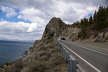
Washoe healers would visit sacred places, such as Cave Rock, to consult with the Water Babies, bringing offerings in the hope of gaining their favor and strength.
The surrounding lakeside area has been developed into a private gated condominium community and some of the buildings of the "Corleone compound" still exist, including the boathouse.