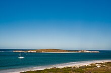
Lancelin Island
The island occupies an area 8.16 hectares (20 acres) and is situated 600 metres (1,969 ft) from the mainland.
[1] It is composed of limestone and is linked to Edwards Island by intertidal and subtidal reef platforms.
The first European to find and name the island was the French explorer Hamelin in 1801 aboard Naturalist.
During World War II the island was used by the Royal Australian Air Force for bombing practice.
Sandier places are dominated by a low heath with shallower soils over limestone areas supporting herbfields and grasslands.