Land-use forecasting
Land-use forecasting undertakes to project the distribution and intensity of trip generating activities in the urban area.
The discussion of land-use forecasting to follow begins with a review of the Chicago Area Transportation Study (CATS) effort.
The rules by which land use was allocated were based on state-of-the art knowledge and concepts, and it hard to fault CATS on those grounds.
The CATS did extensive land use and activity surveys, taking advantage of the City work done by the Chicago Planning Commission.
There is lot of spatial autocorrelation in urban land uses; it's driven by historical path dependence: this sort of thing got started here and seeds more of the same.
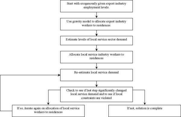
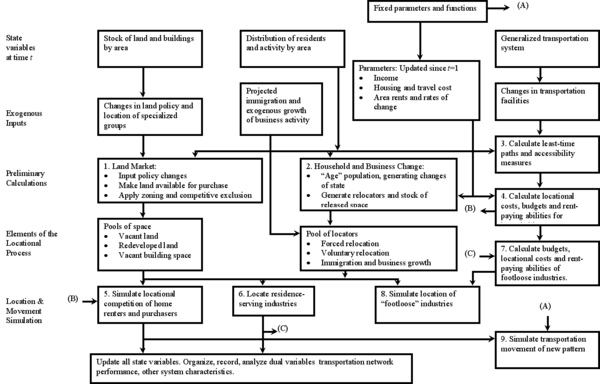
Supported at first by local organizations and later by a Ford Foundation grant to the RAND Corporation, Ira S. Lowry undertook a three-year study in the Pittsburgh metropolitan area.
The environment was data rich, and there were good professional relationships available in the emerging emphasis on location and regional economies in the Economics Department at the University of Pittsburgh under the leadership of Edgar M. Hoover.
It was under much refinement at the time of Lowry's work; persons such as Alan Voorhees, Mort Schneider, John Hamburg, Roger Creighon, and Walter Hansen made important contributions.
Its director's background was in public administration, and leading personnel were associated with the urban planning department at the University of Pennsylvania.
Maximal flow and synthesis problems were also treated (Boldreff 1955, Gomory and Hu 1962, Ford and Fulkerson 1956, Kalaba and Juncosa 1956, Pollack 1964).
Also, there had been a good bit of work in Europe on the interrelations of economic activity and transportation, especially during the railroad deployment era, by German and Scandinavian economists.
Although Alonso's book was not published until 1964, its content was fairly widely known earlier, having been the subject of papers at professional meetings and Committee on Urban Economics (CUE) seminars.
Alonso's urban analysis starting point was similar to Dunn's, though he gave more attention to market clearing by actors bidding for space.
First, there was a spatial price equilibrium perspective, as in Henderson (1957, 1958) Next, Stevens (1961) merged rent and transportation concepts in a simple, interesting paper.
Stevens 1961 paper used the linear programming version of the transportation, assignment, translocation of masses problem of Koopmans, Hitchcock, and Kantorovich.
The Herbert–Stevens model was housing centered, and the overall study had the view that the purpose of transportation investments and related policy choices was to make Philadelphia a good place to live.
wherein xihk is the number of households in group i selecting residential bundle h in area k. The items in brackets are bih (the budget allocated by i to bundle h) and cihk, the purchase cost of h in area k. In short, the sum of the differences between what households are willing to pay and what they have to pay is maximized; a surplus is maximized.
The RAND work ranged from new technology and the cost of tunneling to urban planning models and analyses with policy implications.
After a time, he relocated at the Kennedy School, and he, along with José A. Gómez-Ibáñez, John Meyer, and C. Ingram, lead much work in an economic-policy analysis style.
The notion that the impact of policy on urban development might be simulated was the theme for a conference at Cornell in the early 1960s; collegiums were formed, several streams of work emerged.
CLUG and METROPOLIS are two rather well known products from this stream of work (they were the SimCity of their day); there must be twenty or thirty other similar planner vs. developer in the political context games.
A group at Chapel Hill, mainly under the leadership of Stuart Chapin, began its work with simple analysis devices somewhat similar to those used in games.
Lansing and Muller (1964 and 1967) at the Survey Research Center worked in cooperation with the Chapel Hill Group in developing some of this latter information.
Persons interviewed would be given “money” and a set of housing attributes – sidewalks, garage, numbers of rooms, lot size, etc.
An alternative to the P-J, Herbert-Stevens tradition was seeded when Edwin S. Mills, who is known as the father of modern urban economics, took on the problem of scoping more widely.
Mills treated congestion by assigning integer measures to levels of service, and he considered the costs of increasing capacity.
Mills (1974a,b) permitted exports from non-central zones, and other modifications shifted the ways congestion is measured and allowed for more than one mode of transport.
The best known is Forester (1968), which set off an enormous amount of critique and some follow on thoughtful extensions (e.g., Chen (ed), 1972) Robert Crosby in the University Research Office of the US DOT was very much interested in the applications of dynamics to urban analysis, and when the DOT program was active some work was sponsored (Kahn (ed) 1981).
Thrall introduces a consumption theory of land rent that includes income effects; utility is broadly considered.
Thrall manages both to simplify analytic treatment making the theory readily accessible and develop insights about policy and transportation.