Land change modeling
[1][2] Moreover, developments within land-cover, environmental and socio-economic data (as well as within technological infrastructures) have increased opportunities for land change modeling to help support and influence decisions that affect human-environment systems,[1] as national and international attention increasingly focuses on issues of global climate change and sustainability.
Therefore, decisions and policies in relation to land systems are very important for reacting these changes and working towards a more sustainable society and planet.
[3][4] A plethora of science and practitioner communities have been able to advance the amount and quality of data in land change modeling in the past few decades.
Human-induced impact on the socio-economic and ecological environment is important to take into account, as it is constantly changing land cover and sometimes model uncertainty.
[5] A machine-learning approach uses land-cover data from the past to try to assess how land will change in the future, and works best with large datasets.
These are frequently built for urban areas, such as a 2003 study of the highly dense Pearl River Delta in southern China.
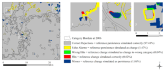
[11] Single summary metrics can obfuscate important information, but the FoM can be useful especially when the hit, miss and false alarm values are reported as well.
[13] Single summary metrics have been overly relied on in the past, and have varying levels of usefulness when evaluating LCMs.
[14] Scientists use LCMs to build and test theories in land change modeling for a variety of human and environmental dynamics.
[15] Land change modeling has a variety of implementation opportunities in many science and practice disciplines, such as in decision-making, policy, and in real-world application in public and private domains.
Research and practitioner communities may study land change to address topics related to land-climate interactions, water quantity and quality, food and fiber production, and urbanization, infrastructure, and the built environment.
Fine data can give a better conceptual understanding of underlying constructs of the model and capture additional dimensions of land use.
It is also important to have better information on land change actors and their beliefs, preferences, and behaviors to improve the predictive ability of models and evaluate the consequences of alternative policies.
It is important to choose the appropriate modeling approach based on the scientific and application contexts of the specific study of interest.
[17] A number of modern challenges in land change modeling can potentially be addressed through contemporary advances in cyberinfrastructure such as crowd-source, “mining” for distributed data, and improving high-performance computing.
For example, modelers can find point-of-sales data on individual purchases by consumers and internet activities that reveal social networks.
[citation needed] The land change modeling community can also benefit from Global Positioning System and Internet-enabled mobile device data distribution.
Combining various structural-based data-collecting methods can improve the availability of microdata and the diversity of people that see the findings and outcomes of land change modeling projects.
Examples in agriculture such as coffee farmers in Avaaj Otalo showed use of mobile phones for collecting information and as an interactive voice.
For example, improving the development of processors, data storage, network bandwidth, and coupling land change and environmental process models at high resolution.