Landes de Gascogne
Before humans began to modify the landscape the Landes de Gascogne was covered by a mixed forest of deciduous and coniferous trees.
On the occasion of certain folk festivals, the shepherds once again become the waders of the Landes of yesteryear, who guarded their flocks, dressed in sheepskins, perched high on their stilts.
The region has undergone a profound transformation as a result of these works which in less than a century have completely changed an economy and a culture that was thousands of years old.
[2] The coastline took on more importance with the development of seaside and resort tourism from the mid-nineteenth century (notably with the arrival of the train from 1841 to La Teste-de-Buch, then to Bayonne and Lacanau).
[3] International competition and technological developments have hit the forest economy hard, but it remains one of the main sources of wealth in Nouvelle-Aquitaine.
[5] The pine forest covered only 2,000 square kilometres (770 sq mi) before systematic afforestation of the dunes and the Landes plateau modified this landscape.
The composition of the massif is changing, with an increasing proportion of deciduous trees, natural or introduced, which has risen from 8% to 15% in the ten years from 2000 to 2010.
Especially since the 1976 drought, the massif has also been a regular victim of attacks by pine processionary caterpillars, bark beetles and other pests to which monospecific stands are particularly sensitive, and has been periodically threatened by forest fires.
It is this last term ager syrticus passed in medieval Latin which appears on the sketches of the first Carolingian maps, above a white space between Bordeaux and Adour, as in the Universal Geography of Anton Friedrich Büsching in the Age of Enlightenment.
Subsequently, several processes would result in what is called the "sands of the Landes": The coast is protected by dunes, with unique vegetation, which deprive many small coastal rivers of access to the ocean and lead to the formation of a string of lakes.
Concerning the history of the vegetation, based on pollen data, the Landes de Gascogne territory was covered by an important diversified forest (oak, elm, lime, ash, beech, pine, etc.)
Although it was subject to regular deforestation from the late Neolithic (around 3500 BC) this forest persisted until the beginning of the Middle Ages (around 600 AD), from which time the intensification of human activities leads in certain sectors to its disappearance and replacement by moorland.
[10] Concerning human occupation, pollen data indicate anthropization dating back to the first half of the Early Neolithic (5,500–6,000 years BC), without archaeological remains to confirm this.
[10][12] (For more information on the Gironde Landes in the 18th century, see Jacques Baurein [fr], Variétés Bordeloises, article XXXIX, pages 412–422.
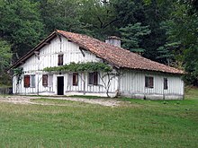
Grouped together in "airials" (small isolated hamlets), they cultivated rye and millet, the basis of their meager diet, and raised sheep whose role was to fertilize the land.
According to historians cows were numerous before the classic image emerged of the Landes shepherd watching from the top of his stilts as his sheep grazed the short heath.
Later François Jules Hilaire Chambrelent [fr] drained the moor by digging ditches, locally called crastes.
This work resulted in the law of 19 June 1857, which required all the municipalities of the Landes de Gascogne to drain their wet moors to enhance them, in particular by afforestation with maritime pine (Pinus pinaster).
The pioneers of the fixation include the Captaux of the de Ruat family who carried out conclusive tests at La Teste-de-Buch at the end of the 18th century.
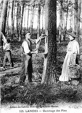
With the disappearance of pastoralism and the massive plantations of maritime pines, the tapping process spread throughout the forest and became a flagship industrial activity of the region until the 1950s.
During World War II, the usual causes of fires in peacetime such as lightning and carelessness were supplemented by causes linked to hostilities such as guerrillas of the French Resistance, plane crashes, landmines in the coastal dunes and scarcity of firefighters.
[16] Faced with the scale of the disasters, at the Liberation of France the Provisional Government of the French Republic issued the Ordinance of 28 April 1945 relating to the development of the Landes de Gascogne region.
The existence of these desert expanses of tens of thousands of hectares practically abandoned by their owners following fires or unregenerated logging resulting from faulty sanitation, is unworthy of a large country like France.
The State must immediately compensate for the powerlessness of the Landes owners by considerable and very urgent works of construction of roads, digging of canals, defense against fires, electrification of the villages and supply of drinking water of the rural populations.
[18] As early as 1948, large credits from the National Forest Fund recently created in 1946 were granted to reforest disaster areas and to equip the massif with preventive means and active control.
While the peasants of the south of Adour were transformed into Landais, the inhabitants of Salles and Saint-Symphorien became unnamed individuals, pale Girondins.
Its missions are preservation of heritage, balanced development of economic activities, and promoting public awareness of their environment by arousing the curiosity of guests and residents.