Great Langdale
It is a popular location for hikers, climbers, fell-runners and other outdoor enthusiasts who are attracted by the many fells ringing the head of the valley.
Great Langdale was an important site during the Neolithic period for producing stone axes and, later, was also one of the centres of the Lakeland slate industry.
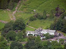
The mouth of the valley is located at Skelwith Bridge, which lies about two miles (three kilometres) west of Ambleside.
The area has outcrops of fine-grained greenstone suitable for making polished axes which have been found distributed across the British Isles.
From below, they appear as a sharp rocky ridge, though they are precipitous only on their southern side; to the north, the land sweeps gently to High Raise, the parent peak of the range.
The Langdale face displays several strata: from the top the Lingmell Formation, Crinkle Member and Bad Step Tuff.
The fell has a small sharp summit, below which rises Gimmer Crag, which is one of the top rock climbing venues in the Lake District.
[4][3][5] Harrison Stickle is the high point of the Langdale Pikes, and its crags fall south and east from the summit, presenting a view from the valley floor 2,000 feet (610 metres) below, or from further afield.
To the north, the main ridge of the central fells passes over Thunacar Knott before climbing to High Raise.
The craggy eastern face of this ridge continues north as far as Harrison's near neighbour, Pavey Ark.
To the southwest, it merges into the crags of Harrison Stickle, while the northern end peters out into the valley of Bright Beck.
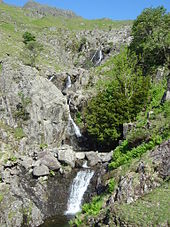
The stone-faced barrage is low enough not to spoil the character of the pool, and the water is used for public consumption in the hotels and homes below.
[7] Letitia Elizabeth Landon's poetical illustration, Langdale Pikes (1832), to a picture by Thomas Allom, ignores the mountains and eulogises on the excellent trout fishing in the river.