Lava Beds National Monument
The region in and around Lava Beds National Monument lies at the junction of the Sierra-Klamath, Cascade, and Great Basin physiographic provinces.
The monument also offers trails through the high Great Basin xeric shrubland desert landscape and the volcanic field.
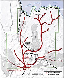
Schonchin Butte cinder cone and the andesitic flow from its base were formed around 62,000 years ago.
ʻAʻā is rough, sharp, and jagged; an excellent example is the Devil's Homestead lava flow, which originated at Fleener Chimneys.
Pumice, a type of rhyolitic lava, also is found covering the monument; this rained down around 900 years ago during the eruption of Glass Mountain.
The oldest lava flow from the Medicine Lake Volcano within the monument is the Basalt of Hovey Point, near Captain Jack's Stronghold, which is 450,000 years old.
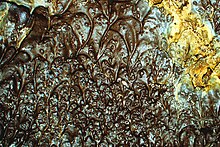
The leaching of minerals from pumice gravel, soils, and overlying rock provides for deposition of secondary speleothems in lava tubes.
The lava tube collapse systems and lava outcrops support a great diversity of plant life, from an impressive variety of lichens and mosses to plants such as desert sweet (Chamaebatiaria millefolium), the aromatic purple desert sage (Salvia dorrii carnosa) and yellow blazing star (Mentzelia laevicaulis).
Some animals obtain water from caves, while others fly about twenty km (12 miles) north to Tule Lake.
Reptile species found in the monument include the northern sagebrush lizard (Sceloporus graciosus graciosus), Great Basin fence lizard (Sceloporus occidentalis biseriatus), western skink (Eumeces skiltonianus skiltonianus), Rocky Mountain rubber boa (Charina bottae utahensis), gopher snake (Pituophis melanoleucus), desert night snake (Hypsiglena torquata deserticola), and western rattlesnake (Crotalus viridis).
Key animal species by habitat: Lava Beds National Monument includes Petroglyph Point, one of the largest panels of Native American rock art in the United States.
[3] During the Modoc War of 1872–1873, warriors of a band led by Kintpuash (Captain Jack) used the lava beds as a defensive stronghold to resist being captured and returned to the Klamath Reservation in Oregon, to which they had been removed, as European Americans wanted their lands.
From this defensive base, a group of 53 fighting men and their families held off US Army forces, amounting to ten times the Modocs' population, for five months.
[10] Howard's perceived need to preserve the lava tubes and the area's other geological features was a major reason why he vigorously pushed for a federally protected status.
"[10] Howard's campaign was successful, as Lava Beds National Monument was signed into existence by President Calvin Coolidge on November 21, 1925.
The western unit covers the monument's area within the transition zone of the Cascade Range's montane southern end and the arid Modoc Plateau ecosystems.
The different soil types creates plant community diversity in the wilderness area, providing various habitats for a wide range of wildlife.
[15] The monument is located on the Pacific Flyway, and the bald eagle winters in the northern portion of the wilderness area.
The National Park Service manages the Lava Beds wilderness area and has several restrictions in place.
[16] The most popular trails are short, but lead to a number of historic sites as to several geological areas within the Lava Beds Wilderness.
These trails are primarily associated with park attractions, especially the Lava Beds geological wilderness, and are sometimes out-and-back day hikes, and in many cases are improved boardwalks and supported with interpretive signs and exhibits.