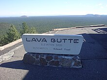
Lava Butte
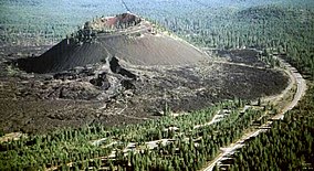
Lava Butte is a cinder cone in central Oregon, United States, just west of U.S. Route 97 between the towns of Bend, and Sunriver in Deschutes County.
The early history of Lava Butte is not known, but it is assumed that Native Americans observed the eruptions and later ascended the prominent new landmark.
In June 1926, a quarry was developed in the fault scarp east of Lava Butte as a source for paving material for the first The Dalles-California Highway (later U.S. Route 97).
In June 1946, widening of the road up Lava Butte to two lanes was completed, along with constructing two small parking lots at the summit.
The original lookout was replaced with a larger one in 1957, which was subsequently enlarged in 1962 to accommodate a small visitor center and museum on the first floor.
In May 1967 the U.S. Forest Service created the 8,983 acres (3,635 ha) Lava Butte Geological Area to protect the cinder cone, with plans for recreational and interpretive development.
Construction of the Lava Lands Visitor Center located just south of the cone began in April 1969 and it was finally dedicated in September 1975.