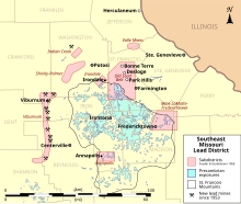
Southeast Missouri Lead District
Counties in the Lead Belt include Saint Francois, Crawford, Dent, Iron, Madison, Reynolds, and Washington.
[2] Austin was the first to sink deep mine shafts and start smelting operations, dramatically increasing lead production.
In 1808, Moses Austin and Samuel Hammond established the city of Herculaneum as a shipping point closer to the mining region, replacing Ste.
In the late 1940s, reserves in the Old Lead Belt began to decline, spurring new mineral exploration in the Southeast Missouri region.
In the Viburnum Trend, lead-zinc ore mineralization is hosted in the bacterial stromatolite reefs dolomites of the upper Bonneterre Formation,[4] and most orebodies are concentrated in areas where the Lamotte Sandstone pinches out against Precambrian igneous knobs and ridges.
Ore mineralization most likely occurred during the Permian, when low-temperature hydrothermal metal-rich brines migrated through the Ozarks during the Ouachita orogeny in the Late Paleozoic.
Ore is mostly constrained to the lower 60 feet of the Bonneterre Formation, and preferentially follow the lateral sedimentary beds and features.
In the Viburnum Trend, zinc and copper are found in higher concentrations, and galena was able to form larger, more euhedral crystals.
Ore mineralization in this subdistrict is prominently emplaced along collapse breccias, and not as influenced by lateral sedimentary features as in the Old Lead Belt.
Ore in the Viburnum Trend can be found throughout the entire vertical extent of the Bonneterre Formation, but is mostly constrained to the upper 75 feet.