Len Beadell
Leonard Beadell OAM BEM FIEMS (21 April 1923 – 12 May 1995) was a surveyor, road builder, bushman, artist and author, responsible for constructing over 6,000 km (3,700 mi) of roads and opening up isolated desert areas – some 2.5 million square kilometres (970 thousand square miles) – of central Australia from 1947 to 1963.
[1] Born in West Pennant Hills, New South Wales, Beadell is sometimes called "the last true Australian explorer".
[2] His father Fred Algernon Beadell was born in Sydney and mother Viola Pearl Mackay was from Townsville.
[2] Richmond had served in the army during World War I, and was employed as a draughtsman and surveyor for the Metropolitan Water, Sewerage and Drainage Board in Sydney.
He went directly to a temporary surveying position with the water board in northern New South Wales, which had been arranged by Richmond.
It was here that Beadell developed his artistic skills by watching army topographical draughtsmen, whose job it was to draw maps from information supplied by surveyors.
[7] In November 1949, he was asked to rejoin the project and began further surveying as an employee of the Long Range Weapons Establishment in August 1950.
The road was built with initial reconnaissance and survey by Len (not the case in 1958 when the survey reconnaissance from Warburton to Carnegie was led by the Supervising Surveyor (Geodetic) Australian Division of National Mapping, Mr HA (Bill) Johnson MBE LS FIS Aust [9]), usually alone, pushing through raw scrub in a Land Rover.
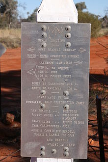
[2] The Gunbarrel Highway was begun at Victory Downs homestead[10] 316 km (196 mi) by road south of Alice Springs.
It then pushed west to the Rawlinson Ranges, skirting south of the Gibson Desert, via the mission at Warburton, to connect to an existing road at Carnegie Station.
Len suffered near starvation, many mechanical breakdowns, countless punctures and other mishaps, all in searing desert heat, but seemingly took it all in his stride with good humour.
[2] The description stuck, and maps show the subject roads as highways, despite the reality that they have degraded to single lane unsealed tracks through the remote arid areas of central Australia.
Beadell chose and surveyed the location for the Giles Meteorological Station and airstrip during construction of the Gunbarrel Highway.
[13] During a break from construction of the Gunbarrel Highway in June 1957, Beadell convinced a visiting dental surgeon at Woomera, Dr Bruce Dunstan, to give him a crash course on tooth extraction.
This instruction and further assistance from an Alice Springs dentist, Ray Meldrum, equipped him with dental supplies and local anaesthetics sufficient for bush work.
[2] Len Beadell marked "astrofixes" along his roads with aluminium plates on which latitude, longitude and other information was stamped.