Lents, Portland, Oregon
The Lents neighborhood in the Southeast section of Portland, Oregon is bordered by SE Powell Blvd.
[4] Because of its distance from central Portland and lower income residents, the neighborhood suffered delays in getting street and sewer improvements.
By the time it came to final planning in the 1970s, the city had grown and decided to move the freeway's path further out to 96th Avenue, effectively cutting the Lents neighborhood in half.
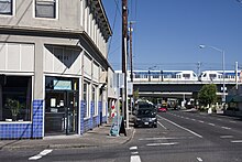
Interstate 205 and three of Portland's important arterials—Powell Boulevard, Foster Road and 82nd Avenue—pass through the neighborhood, as well as the MAX Green Line and the Springwater Corridor pedestrian and bike trail.
The MAX light rail system has been expanded southward from the Gateway hub, along I-205 to the Clackamas Town Center.
[7] In September 1998, the City Council established a Lents Town Center Urban Renewal Area (LTCURA) in order to accomplish community goals.
On May 8, 2007, PDC staff presented an overview of the plan amendment study process to the Lents Town Center Urban Renewal Advisory Committee (URAC and requested their project ideas for consideration, concerns, and feedback.
Moving forward, the Lents Town Center Plan Amendment Study revisited the existing urban renewal boundary (2,472 acres) and explored an increase in maximum indebtedness to fund community development projects.
The First Amendment to the Lents Town Center Urban Renewal Area will expand boundaries by 140.05 acres (0.5668 km2), increase maximum indebtedness by $170 million and extend the expiration date to June 30, 2020.