Lidar
[9] NASA has identified lidar as a key technology for enabling autonomous precision safe landing of future robotic and crewed lunar-landing vehicles.
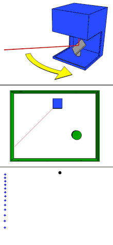
Intended for satellite tracking, this system combined laser-focused imaging with the ability to calculate distances by measuring the time for a signal to return using appropriate sensors and data acquisition electronics.
[17][15] The first mention of lidar as a stand-alone word in 1963 suggests that it originated as a portmanteau of "light" and "radar": "Eventually the laser may provide an extremely sensitive detector of particular wavelengths from distant objects.
It can target a wide range of materials, including non-metallic objects, rocks, rain, chemical compounds, aerosols, clouds and even single molecules.
In these devices each pixel performs some local processing such as demodulation or gating at high speed, downconverting the signals to video rate so that the array can be read like a camera.
The chip uses indium gallium arsenide (InGaAs), which operates in the infrared spectrum at a relatively long wavelength that allows for higher power and longer ranges.
[40] The two types require scanners with varying specifications based on the data's purpose, the size of the area to be captured, the range of measurement desired, the cost of equipment, and more.
Within the category of airborne lidar, there is sometimes a distinction made between high-altitude and low-altitude applications, but the main difference is a reduction in both accuracy and point density of data acquired at higher altitudes.
Airborne lidar digital elevation models can see through the canopy of forest cover, perform detailed measurements of scarps, erosion and tilting of electric poles.
The laser is directed at the region to be mapped and each point's height above the ground is calculated by subtracting the original z-coordinate from the corresponding digital terrain model elevation.
Based on this height above the ground the non-vegetation data is obtained which may include objects such as buildings, electric power lines, flying birds, insects, etc.
Turbidity causes scattering and has a significant role in determining the maximum depth that can be resolved in most situations, and dissolved pigments can increase absorption depending on wavelength.
[54] Agricultural robots have been used for a variety of purposes ranging from seed and fertilizer dispersions, sensing techniques as well as crop scouting for the task of weed control.
Lidar is useful in GNSS-denied situations, such as nut and fruit orchards, where foliage causes interference for agriculture equipment that would otherwise utilize a precise GNSS fix.
Lidar sensors can detect and track the relative position of rows, plants, and other markers so that farming equipment can continue operating until a GNSS fix is reestablished.
[64] In southern New England, lidar was used to reveal stone walls, building foundations, abandoned roads, and other landscape features obscured in aerial photography by the region's dense forest canopy.
[100][101][102] Using southern bull kelp in New Zealand, coastal lidar mapping data has been compared with population genomic evidence to form hypotheses regarding the occurrence and timing of prehistoric earthquake uplift events.
Other statistical analysis use lidar data to estimate total plot information such as canopy volume, mean, minimum and maximum heights, vegetation cover, biomass, and carbon density.
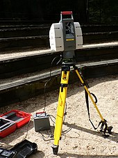
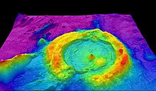
[106] High-resolution digital elevation maps generated by airborne and stationary lidar have led to significant advances in geomorphology (the branch of geoscience concerned with the origin and evolution of the Earth surface topography).
The term, eolics, has been proposed to describe the collaborative and interdisciplinary study of wind using computational fluid mechanics simulations and Doppler lidar measurements.
Few military applications are known to be in place and are classified (such as the lidar-based speed measurement of the AGM-129 ACM stealth nuclear cruise missile), but a considerable amount of research is underway in their use for imaging.
Examples of military applications of lidar include the Airborne Laser Mine Detection System (ALMDS) for counter-mine warfare by Areté Associates.
Short-range compact spectrometric lidar based on Laser-Induced Fluorescence (LIF) would address the presence of bio-threats in aerosol form over critical indoor, semi-enclosed and outdoor venues such as stadiums, subways, and airports.
This near real-time capability would enable rapid detection of a bioaerosol release and allow for timely implementation of measures to protect occupants and minimize the extent of contamination.
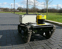
[132] Five lidar units produced by the German company Sick AG were used for short range detection on Stanley, the autonomous car that won the 2005 DARPA Grand Challenge.
[139] At the JET nuclear fusion research facility, in the UK near Abingdon, Oxfordshire, lidar Thomson scattering is used to determine electron density and temperature profiles of the plasma.
By precisely timing the lidar echo, and by measuring how much laser light is received by the telescope, scientists can accurately determine the location, distribution and nature of the particles.
[177] Recent airborne laser scanning efforts have focused on ways to estimate the amount of solar light hitting vertical building facades,[178] or by incorporating more detailed shading losses by considering the influence from vegetation and larger surrounding terrain.
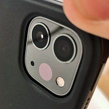
[183] In 2020, Apple introduced the fourth generation of iPad Pro with a lidar sensor integrated into the rear camera module, especially developed for augmented reality (AR) experiences.
In 2022, Wheel of Fortune started using lidar technology to track when Vanna White moves her hand over the puzzle board to reveal letters.