Liber Secretorum Fidelium Crucis
[1] It was begun in March 1306, and finished (in its earliest form) in January 1307, when it was offered to Pope Clement V as a manual for true Crusaders who desired the reconquest of the Holy Land.
The crusading plans of the Secreta are double: first, Egypt and the Muslim world on the side towards Europe (Syria, Asia Minor, the Barbary States (North Africa), Granada, etc.)
By such an interdict Sanuto hopes that Egypt, dependent on its European and other imports of metals, provisions, weapons, timber, pitch and slaves, would be fatally weakened, and the way thus prepared for the second part of the campaign the armed attack of the crusading fleet and army on the Nile delta.
Finally, after the conquest of Egypt, Marino designs the establishment of a Christian fleet in the Indian Ocean to dominate and subjugate its coasts and islands.
Among the plans that of Acre is of peculiar interest, being the most complete representation known of the great crusading fortress on the eve of its destruction, with the quarters of all its contingents of defenders (Templars, etc.)
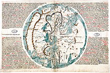
Africa, away from the Mediterranean, is conventional, with its south-east projected, after the manner of Idrisi, so as to face Indian Asia, and with a western Nile traversing the continent to the Atlantic.
Chinese and Indian Asia show little trace of the new knowledge which had been imparted by European pioneers from the Polos' time, and which appears so strikingly in the Catalan Atlas of 1375.
Sanuto's Palestine map is remarkable for its space-defining network of lines, which roughly answer to a kind of scheme of latitude and longitude, though properly speaking they are not scientific at all.