Muhammad al-Idrisi
Abu Abdullah Muhammad al-Idrisi al-Qurtubi al-Hasani as-Sabti, or simply al-Idrisi /ælɪˈdriːsiː/ (Arabic: أبو عبد الله محمد الإدريسي القرطبي الحسني السبتي; Latin: Dreses; 1100–1165), was a Muslim geographer and cartographer who served in the court of King Roger II at Palermo, Sicily.
[1][2] Al-Idrisi was believed to be born the city of Ceuta in 1100, at the time controlled by the Almoravids, where his great-grandfather had been forced to settle after the fall of Hammudid Málaga to the Zirids of Granada.
[3] He spent much of his early life travelling through North Africa and Al-Andalus (Muslim Spain and Portugal of the times) and seems to have acquired detailed information on both regions.
[citation needed] Because of conflict and instability in Al-Andalus al-Idrisi joined contemporaries such as Abu al-Salt in Sicily, where the Normans had overthrown Arabs formerly loyal to the Fatimids.
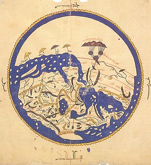
Al-Idrisi incorporated the knowledge of Africa, the Indian Ocean and the Far East gathered by Islamic merchants and explorers and recorded on Islamic maps with the information brought by the Norman voyagers to create the most accurate map of the world in pre-modern times,[5] which served as a concrete illustration of his Kitab nuzhat al-mushtaq, (Latin: Opus Geographicum), which may be translated A Diversion for the Man Longing to Travel to Far-Off Places.
[6] The Tabula Rogeriana was drawn by al-Idrisi in 1154 for the Norman King Roger II of Sicily, after a stay of eighteen years at his court, where he worked on the commentaries and illustrations of the map.
The relative position of the lakes which form the Nile, as delineated in his work, does not differ greatly from that established by Baker and Stanley more than seven hundred years afterwards, and their number is the same.
The celestial and terrestrial planisphere of silver which he constructed for his royal patron was nearly six feet in diameter, and weighed four hundred and fifty pounds; upon the one side the zodiac and the constellations, upon the other-divided for convenience into segments-the bodies of land and water, with the respective situations of the various countries, were engraved.
Although historians note that both al-Idrisi and the Norse tend to understate distances, the only location this reference is thought to have possibly pointed to, must likely have been in Greenland.
[13] The translated title of this work (in the "pleasure of him ..." form) attracted favourable comment from the team selecting lists of names for features expected to be discovered by the New Horizons probe reconnoitring the Pluto system.
[13] An abridged version of the Arabic text was published in Rome in 1592 with title: De geographia universali or Kitāb Nuzhat al-mushtāq fī dhikr al-amṣār wa-al-aqṭār wa-al-buldān wa-al-juzur wa-al-madā' in wa-al-āfāq which in English would be Recreation of the desirer in the account of cities, regions, countries, islands, towns, and distant lands.
The Maronites Gabriel Sionita and Joannes Hesronita translated an abridged version of the text which was published in Paris in 1619 with the title of Geographia nubiensis.
Furthermore, al-Idrisi writes an account of eight Mugharrarin all from the same family who set sail from Lisbon (Lashbuna) in the first half of that century and navigated in the seaweed rich seas beyond the Azores.
[23] Among the lesser known works of al-Idrisi is a medical dictionary that he compiled in which he brings down a list of simple drugs and plants and their curative effects, used by physicians, apothecaries and merchants in his day.