List of gaps in Interstate Highways
These gaps can be due to unconnected segments of the same route or from failure of the road to fully conform to Interstate standards by including such characteristics as at-grade crossings, traffic lights, undivided or narrow freeways, or movable bridges (lift bridges and drawbridges).
[9] The section from Memphis to Houston is the least developed; as of 2021, Mississippi has no current plans to extend I-69 further south, and the states of Louisiana and Arkansas have not funded construction of their portion of the proposed route (via El Dorado and Shreveport) between Mississippi and Texas, other than a two-lane southern bypass of Monticello, Arkansas designed to be incorporated into I-69 at a later date.
One travels for 197 miles (317 km) from I-90 in North East, Pennsylvania (which is a town in the northwestern part of the state) to exit 61 in Waverly, New York.
Much of the intervening route, including the entire US 15 section between I-180 in Williamsport and the New York state line, has been constructed to freeway standards but as of yet is not signed as part of I-99.
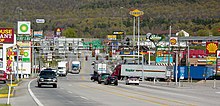
In urban and heavily developed areas, Interstates may travel along surface roads or have at-grade intersections with stop signs or traffic lights.
This usually happens because the Interstate started construction after the land was heavily developed and buildings such as residences and businesses and other roads would have to be removed to allow a freeway to pass through.
Additionally, more developed land would have to be cleared for space to build interchanges to connect the Interstate and surface streets.
This situation is extremely uncommon as Interstates are usually built around cities or through them on pre- or lightly developed land.
Several Interstates in rural areas of the U.S. have minor at-grade intersections (including median breaks) with farm access roads or authorized vehicle-only driveways used for highway maintenance or connection to nearby utility stations.
This is usually due to the lack of an old highway, the need to provide access to property that was accessed via the road prior to its upgrade to an Interstate, and the high cost to construct an interchange for the small amount of traffic that would use such a connection or to build a frontage road parallel to the freeway to the nearest interchange.
Narrow gaps between opposing directions with jersey barriers taller than four feet (1.2 m) are excluded from this section; therefore the separation criterion is really either a 4-foot-tall (1.2 m) wall, or a 100-foot-wide (30 m) median, whichever is greater.
Freeway gaps (signed or unsigned) that officially connect auxiliary routes to the parent are excluded.