Geography of Abkhazia
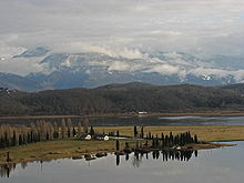
Abkhazia covers an area of about 8,660 square kilometres (3,340 sq mi)[1] at the western end of Georgia, on the north shore of the Black Sea.
[1] Southeastern Abkhazia, a part of the Colchis Lowland, is still covered by Colchian forests (alder, hornbeam, oak, beech), or by citrus and tea plantations.
The latest survey (as of September 2007) has measured the vertical span of this cave system as 2,191 m (7,188 ft) between its highest and lowest explored points.
The foothills, up to an elevation of 600 meters (1,969 ft) above sea level, are covered by deciduous forests (with evergreen elements), and include tree species such as oak, hornbeam, beech, and buxus.
The mixed forest zone is home to some of the tallest trees in Europe and the world, where some specimens of the Nordmann Fir (especially around Lake Ritsa) reach heights of over 70 meters (230 ft).
The Caucasus Mountains are greatly responsible for moderating the region's climate, as they shield Abkhazia from cold northerly winds.
Higher elevations of Abkhazia, above 1,000 meters (3,281 ft) above sea level have a maritime, mountain climate, experiencing relatively cold winters and long, warm summers.
Abkhazia receives high amounts of precipitation, but is known for its unique micro-climate (transitional from subtropical to mountain) along most of its coast, causing lower levels of humidity.