Little Butte Creek
Little Butte Creek's watershed was originally settled by the Takelma, and possibly the Shasta tribes of Native Americans.
Coho and Chinook salmon migrate upstream each year; however, several dams hinder their progress.
Restoration of a 1.3-mile (2.1 km) artificially straightened section of the creek in the Denman Wildlife Area was completed in 2011.
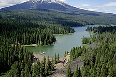
Little Butte Creek begins in the Cascade Range near Mount McLoughlin and Brown Mountain.
[4] Just after the two forks merge about 15 miles (24 km) northeast of Medford,[12] Little Butte Creek receives Lake Creek on the left bank, flowing through the community of the same name at river mile (RM) 17 or river kilometer (RK) 27.
[3] Water is diverted here into the Joint System Canal for storage in Agate Lake and to provide irrigation for the Medford region.
[4][23] The High Cascades compose the eastern third of the watershed, including volcanoes such as Brown Mountain and Mount McLoughlin, and lava plateaus.
In the summer, many streams are over-appropriated, leading to frequent water shortages along the lower portion of the creek.
[4][24] The flora in the Little Butte Creek watershed is predominately temperate coniferous forest, which makes up approximately 65 percent of the total area.
The mixed coniferous forest is home to white-headed woodpeckers, pygmy nuthatches, green-tailed towhees, northern pygmy-owls, Vaux's swifts, winter wrens, and MacGillivray's warblers.
[27] Williamson's sapsuckers, black-backed woodpeckers, Canada jays, and hermit warblers frequent the higher elevations.
[29] The most common anadromous fish inhabiting the creek include chinook and coho salmon, and sea-run cutthroat trout.
The Southern Oregon/Northern California Coast Coho Salmon Evolutionary Significant Unit is listed as threatened (2011).
[30] Coho salmon are known to spawn in 46 miles (74 km) of streams in the Little Butte Creek watershed.
[4][12] The Little Butte Creek area was originally settled by the Takelma,[4] and possibly the Shasta tribe of Native Americans.
A. Lupton gathered 35 men from Jacksonville on October 8, 1855, and attacked the Native Americans near the mouth of Little Butte Creek, killing about 30 of them.
[33] On December 24 of the same year, Captain Miles Alcorn discovered and attacked a Native American camp on the north fork, killing eight.
[34] On Christmas, the following day, another band of Native Americans were attacked near Little Butte Creek's mouth; some fled, while the rest were either captured or killed.
[44] In 1956, the United States Bureau of Reclamation awarded a contract to Portland, Oregon-based Lord Brothers to build the Deadwood Tunnel.
Water from Howard Prairie Lake is diverted into the canal west to Keene Creek Reservoir, about 16 miles (26 km) east of Ashland.
[42] The water eventually ends up in Emigrant Lake, about 8 miles (10 km) southeast of Ashland, where it either continues along Bear Creek, or is diverted for irrigation.
[50] The mill is now included on the National Register of Historic Places, and is the only gristmill in Oregon to still grind flour.
[57] The straightness forced water downward instead of outward like a typical creek, scouring the stream bed down to bedrock and creating an unsuitable habitat for wild salmon.
[57] The $700,000 project involved building engineered riffles and log jams and adding boulders, extending the creek by approximately 3,500 feet (1,100 m).
[58][59] The Oregon Department of Environmental Quality (DEQ) has monitored Little Butte Creek for eight different parameters that affect water quality: temperature, oxygen saturation, pH, nutrients, bacteria, chemical contaminants such as pesticides and metals, turbidity, and alkalinity.
Streams that exceed the standard level are then placed on the DEQ 303d list in accordance with the Clean Water Act.
The entire main stem exceeded the standard level for temperature, oxygen saturation, fecal coliforms (bacteria), and turbidity.
Another threat to healthy riparian zones are invasive blackberries, which crowd out native vegetation and provide little shade.
The average for Little Butte Creek at RM 1.4 (RK 2.3) between 1998 and 2007 was 72 (poor) in the summer and 82 (fair) in the fall, winter, and spring.
[62] The Denman Wildlife Area is at the mouth of Little Butte Creek, as is nearby TouVelle State Park.