Little Thetford
The village is built on a boulder clay island surrounded by flat fenland countryside, typical of settlements in this part of the East of England.
The Roman road Akeman Street passed through the north-west corner of the parish, and the lost 7th century Anglo-Saxon village of Cratendune may be nearby.
[2][3] The 10th-century Old English name, lȳtel Thiutforda, suggests a ford across the nearby River Great Ouse, which today forms most of the village's eastern boundary.
Little Thetford resisted the parliamentary inclosure acts of William IV for seven years, which may have led to the strong Baptist following amongst the poor of the village.
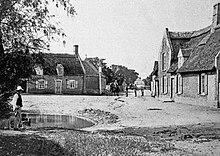
Occupying an area of 2 square miles (5 km2), and with a population of 792, Little Thetford is the smallest civil parish in the ward of Stretham; notable buildings in the village date from the 14th century.
A 1996 search along the Anglian Water pipeline at Little Thetford—Cawdle Fen uncovered an important and unusually dense concentration of late Neolithic (3000–2201 BC) remains.
[4] This is unusual because, although the fenland basin was dry and forested during the Mesolithic era, the area was sometimes subject to marine incursions, and at other times, fresh-water flooding.
[7] A more substantial Bronze Age settlement is known to have existed; the remains of what may have been a causeway were discovered in 1934, in the form of wooden piles unearthed by a farmer between Little Thetford and nearby Barway.
[11] A Romano-British farm around 200 AD, largely built upon a previous Iron Age settlement dating from 200 to 100 BC, was discovered during the Watson's Lane development in 1994.
In 673 AD, Æthelthryth considered restoring this church, thought to have been destroyed by Penda of Mercia, but instead made what is now Ely Cathedral the site of her monastery.
The will of Ælfwaru (d. 1007), an Anglo-Saxon noblewoman, granted estates in Cambridgeshire and Norfolk to the Abbey, which included "... that land at Thetford[22] and fisheries around those marshes".
[30] The apothecary and botanist William Sole (June 1741 February 1802) was born in Little Thetford[nb 3] and educated at King's School, Ely.
Sole published Menthae Britannicae; he was one of the first elected associates of the Linnean Society of London and Sprengel named a plant species Solea (now Viola) after him.
They returned later with ten constables, authorised by Ely magistrates, and were confronted this time by 150 stick-wielding protesters, who continued to prevent due process.
The villagers saved the nearby Three Horseshoes public house, by forming a bucket chain, and pouring water on its thatched roof.
Another villager, serving on board HMS Warspite, was fatally wounded at Salerno during his ship's support of the Allied invasion of Italy.
The rain running off the frozen ground, combined with the thaw, overwhelmed multiple rivers in England and eastern Wales, which flooded.
Parish council services include bus shelters, cemeteries, shared equity housing, local planning consultation, play areas, village halls, and war memorials.
The county council provides county-wide services such as major road infrastructure, fire and rescue, libraries and heritage, and strategic planning.
The village, which is at about 16 feet (5 m) above sea-level, sits largely on the Kimmeridge Clay, a Jurassic shallow-water shelf-sea deposit, with an overall south-south-east to south-east dip.
[54] Overlying the Kimmeridge Clay and lying some distance to the east of the village are similarly dipping, younger Cretaceous rocks, comprising the Greensand and Chalk.
This hill is capped by much younger (Pleistocene) boulder clay, the result of large ice sheets having moved over the wider general area.
Northwards, an even larger outlier of Greensand, partly capped by glacial deposits, forms a hill rising to 85 feet (26 m) above sea-level.
[55][56] Even more geologically recent gravel, alluvium and fen deposits are found in the valley of the River Great Ouse at the eastern end of the village; they merge into the extensive flat tracts of The Fens which stretch north-north-west towards The Wash.[54][55][56] Holme at nine feet (2.75 m) below sea-level is East Cambridgeshire's (and the United Kingdom's) lowest point, and is 22 miles (35 km) north-west.
The northern boundary of the village extends from the north of Bedwell Hey Farm then eastwards across the A10 road to the River Great Ouse.
Protected from the cool onshore coastal breezes east of the region, Cambridgeshire is warm in summer and cold and frosty in winter.
[79] One author attributes the Stretham coprolite pit, in Little Thetford, as being owned by John Bailey Denton, 1814–1893, the surveyor and civil engineer.
[83] There was a public house at Little Thetford, the Fish and Duck, situated along the river nearer Stretham;[84] it closed in 2006,[85][86] and the owning company dissolved on 11 May 2010.
A privately owned 1945 de Havilland Dragon Rapide, based at the Shuttleworth Trust's Old Warden airfield, passes over the village during sightseeing tours to Ely.
Villagers have voiced a number of objections, such as the in-camera land selection process, and apparent undeclared conflicts of interest amongst the trustees.


Joan Blaeu (1648) Regiones Inundatae


