Loess Hills
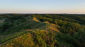
The Loess Hills rise 200 feet (60 m) above the flat plains forming a narrow band running north–south 200 miles (320 km) along the Missouri River.
During the last Ice Age, glaciers advanced into the middle of North America, grinding underlying rock into dust-like "glacial flour."
The heavier, coarser silt was deposited close to the Missouri River flood plain, forming vast dune fields.
Due to the erosive nature of loess soil and its ability to stand in vertical columns when dry, the stabilized dunes were eroded into the corrugated, sharply dissected bluffs we see today.
The soil has a characteristic yellow hue and is generally broken down into several units based on the period of deposition (Loveland, Pisgah, Peoria).
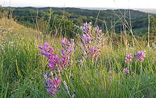
Many of the prairie species found in the Loess Hills are outside of their normal range of distribution, with plants like spiny-leafed yucca and prickly pear cactus being more common further west, in the Sandhills of central Nebraska.
Common fauna of the modern Loess Hills include white-tail deer, coyote, wild turkey, badger, bobcat, red and gray fox, ringneck pheasant, bobwhite, and red-tailed hawk, some of which were introduced or encouraged by Euro-American settlers.
Fauna more typical of the pre-settlement Loess Hills, such as the prairie rattlesnake, great plains skink, plains pocket mouse, ornate box turtle and spadefoot toad, are becoming rare and even endangered due to habitat fragmentation as a result of increased development and suppression of fire in prairie remnants and oak savannas.
Historically, fauna also included American bison, prairie chicken, mule deer, elk, and gray wolf; these were extirpated by the late nineteenth century.
The prevailing winds across the floodplain then hit the sharp rise of the Loess Hills, creating thermal updrafts that raptors use to make their way to and from breeding grounds.
While much of the landscape is held in private ownership, thousands of acres of public land exist in state and county parks, wildlife areas and preserves.
The Nature Conservancy also owns several preserve areas in the Hills which are open to the public, including Broken Kettle Grasslands Preserve—the largest contiguous tract of native prairie left in Iowa.
The Glenwood Culture lived in the area from roughly 900 A.D. to 1300 A.D. and built hundreds of earth lodges in the region, farming the rich valley bottoms and cultivating native plants from the surrounding hills.
Charles Floyd, the only fatality of the Lewis and Clark Expedition, is buried on a bluff in the Loess Hills in what is now Sioux City, Iowa.
Loess soil also forms the Arikaree Breaks in northwest Kansas, and the Mississippi-Yazoo "Bluff Hills" near Vicksburg, Mississippi.