Loktak Lake
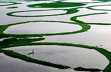
[5][4] It is famous for the phumdi (heterogeneous mass of vegetation, soil and organic matter at various stages of decomposition) floating over it.
[7][8][9][10] Considering the ecological status and its biodiversity values, the lake was initially designated as a wetland of international importance under the Ramsar Convention on 23 March 1990.
[14] Geographically, in terms of biodiversity and pressure of human activities, the lake is broadly divided into northern, central and southern zones as elaborated below.
Grey sandstone–grit–conglomerate–limestone sequences intruded by serpentinites containing minor amounts of enstalite, chromite, amphiboles and magnetite constitute the Disang formation.
[16] The Loktak Lake is fed by the Manipur river and several tributaries and ‘Ungamel Channel’ (Ithai Barrage) is its only outlet now.
[6] Several water resources development projects have been built in the Manipur River basin to meet growing demands for irrigation.
The main components of the project, as built, are, a) the Ithai Barrage, across the Manipur river of 10.7 m (35.1 ft) height and 58.8 m (192.9 ft) length with three spillway bays, b) water conductor system for trans-basin diversion comprising an open channel of 2.323 km (1.443 mi) length, a cut and cover section of 1.077 km (0.669 mi) length (bed width 18 m (59 ft), followed by a Head Race Tunnel of 3.81 m (12.5 ft) diameter (horseshoe type) and 6.62 km (4.11 mi) long to carry a discharge of 58.8 m3/s (2,080 cu ft/s) (42 m3/s (1,500 cu ft/s)) for power generation and 16.8 m3/s (590 cu ft/s) for irrigation), c) a surge shaft, d) penstocks and e) a surface powerhouse and a tailrace channel on the right bank of the narrow Leimatak River with three units of 35 MW capacity each generating an annual energy of 448 GW·h (1.613 PJ).
[19] The lake’s rich biological diversity comprises 233 species of aquatic macrophytes of emergent, submergent, free-floating and rooted floating leaf types.
[19] In the habitat patch with rooted floating plants, vegetation comprises the a) Nelumbo nucifera, b) Trapa natans, c) Euryale ferox, d) Nymphaea alba, e) N. nouchali, N. stellata and f) Nymphoides indica.
In the habitat part of the rooted plants, Hydrophasianus chirurgus, Metopidius indicus, and others were reported; once abundant now show a declining trend.
Fifty percent of the fingerlings produced were released into the Loktak Lake and the balance were distributed to beneficiary fishing committees.
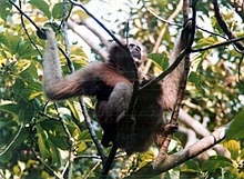
Fauna recorded in the precincts of the Lake in the Keibul Lamjo National Park are the Indian python, sambar, barking deer, the endangered sangai species of Eld's deer, wild bear, Muntiacus muntjak, rhesus monkey, hoolock gibbon, stump-tailed macaque, Indian civet Viverra zibetha, marbled cat and Temminck's golden cat.
Deforestation and shifting cultivation in the catchment areas have accelerated the process of soil erosion resulting in the lake’s shrinkage due to siltation.
[15][23] The construction of Ithai barrage and maintaining constant water level at full reservoir level (FRL) has led to a) changes in hydrological regime thereby affecting ecological processes and functions of the wetland, b) inundation of agricultural lands and displacement of people from flooded lands and c) loss of fish population and diversity.
[25] The thickness of phumdis has decreased in the Keibul Lamjao National Park thereby threatening the survival of sangai deer and interference in the migration of fishes from the Chindwin–Irrawaddy River system of Myanmar resulting in changes in the species composition.
Production of the edible fruit and rhizome (thamchet and thambou) of lotus plants has decreased to a great extent.
A Project Report titled "Sustainable Development & Water Resources Management of Loktak Lake (SDWRML)" has been prepared.
The report gives a review of its activities on the project done for over six years (from 1 February 1998 till the end of March 2004) with the following pertinent observations.
[27] Based on all the analysis, the future approach suggested involves mitigation measures as elaborated are: i) The Nambol River carries sewage of nutrients of Imphal town into the lake which results in prolific growth of phumdis and deteriorates water quality.
This is an urban problem and there is urgent need to treat and control this aspect, even if it is expensive; ii) Reduce soil erosion and sedimentation of the lake by enlarging the scope of micro-watersheds in the catchment area treatment plan; iii) Construct a channel through the Keibul Lamjao National Park to enable phumdis to settle at the bed of the lake; iv) Resolve the encroachment problem, by demarcating the lake boundary, which would result in a targeted and concerted action plan; v) Implement action plans that are economically viable and technically feasible resulting in livelihood enhancement such as evolving an attractive resettlement plan for the phumdi dwellers backed by remunerative livelihood program; and vi) Examine introduction of fishing net instead of Athapum (Athapam means phumdis in circular shape floating in the lake, planted or cultured artificially for catching fish) practiced presently to be dismantled.
In November 2016, Environment ministry has taken keen interest in preserving loktak lake and has formed a panel of five members for this purpose.
Visitors get a bird's eye view of life on the lake—small islands that are actually floating weed on which the lake people live.
[30] At Moirang town on the fringe of the Loktak is the Indian National Army (INA) Museum which will be of interest to tourists.