Long's Expedition of 1820
The Stephen H. Long Expedition of 1820 traversed America's Great Plains and up to the foothills of the Rocky Mountains.
Lewis and Clark (1803–1806) and Zebulon Pike (1805–1807) explored the western frontier but they were primarily military expeditions.
The expensive effort was cancelled following a financial crash, steamboat failures, operational scandals, and negotiation of the Adams–Onís Treaty of 1819, which changed the border between New Spain and the United States.
[3] The Yellowstone expedition, authorized by Secretary of War John C. Calhoun, was a "grandiose" plan to build a number of military outposts along the upper Missouri River.
[6][7] Continuing on the Missouri River, the scientists occasionally left the boat to find and document flora and fauna.
[5] The lean budget meant that the party did not have the men, horses, food, and equipment required for a journey of this scope and length of time.
[1] They were warned by white and Native American people against the trip because they would be passing through dry, barren lands, with inadequate supplies, and subject to hostilities with Indigenous nations.
[10] The scientists were tasked to document the natural resources and the Native Americans, and to map the area that they traversed through the Great Plains.
[3] Long said that he wanted all vegetation, land and water life, and geological formations to be studied and documented, along with diseases of animals and insects.
[2] Major Stephen Harriman Long, a topographical engineer and scientist with the United States Army, led the party through the first military and scientific reconnaissance of the Great Plains.
[4] Corporal Parish and six privates of the Sixth Infantry Regiment, as well as guides and hunters, accompanied Long's expedition.
The pack animals carried food, camping equipment, rifles, tools necessary for scientific and topographical study, and specimen containers.
[18] In the early days of their expedition, they passed Pawnee villages and traveled through mostly treeless prairie and were subject to thunderstorms.
They recorded sighting of Bartram's sandpiper, marbled godwits, and other birds and a number of plants, including rabbits foot plaintain and sweet peas.
After crossing Beaver Creek, they met up with three Frenchmen and two Native Americans who were carrying vaccine supplied by the Department of War for the Pawnee.
[16] Traveling southwest, the climate and terrain was more desert-like, with shallow rivers, and bright sunlight that bounced off the sand and hurt their eyes.
A few men decided to follow the South Platte further up the mountains, but they became ill, likely due to altitude sickness.
The expedition next headed south towards the Arkansas River, stopping to enjoy the views of what is now Roxborough State Park.
Long took a side journey to the top of Dawson Butte (southwest of Castle Rock, while some of the men traveled along Rampart Range, discovering the dusky grouse and band-tailed pigeon.
[25] It was found in present day Douglas County near Elephant Rock amongst oak brush land, grassland, and ponderosa pine forest.
In addition to other animals that they saw earlier on their trek, they saw kangaroo rats, a white grizzly bear, robins, and many beaver dams.
It was an area full of wildlife, in addition to other animals that they saw previously, they found wild turkeys, burrowing owls, mule deer, and a mockingbird.
They lost their supply of fresh water after the creek overflowed during rainstorms, mixing with "historic accumulations of bison dung".
[29] Having run out of food, the men hunted for deer and buffalo, but there were not sufficient resources that summer to adequately feed them.
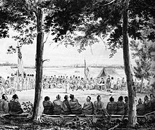
[1] During the expedition, the team met up with Arapaho, Cheyenne, Comanche, and Kiowa people in Colorado and Oklahoma.
By the time that White Americans settled in the Plains, the technology existed for successful deep-well drilling and use of barbed wire.