Los Angeles Basin
The present basin is a coastal lowland area, whose floor is marked by elongate low ridges and groups of hills that is located on the edge of the Pacific plate.
[2] The majority of the jurisdictional land area of the city of Los Angeles physically lies within this basin.
On the north, northeast, and east, the lowland basin is bound by the Santa Monica Mountains and Puente, Elysian, and Repetto hills.
[4] The Los Angeles Basin is notable for its great structural relief and complexity in relation to its geologic youth and small size for its prolific oil production.
[3] Yerkes et al. identify five major stages of the basin's evolution, which began in the Upper Cretaceous and ended in the Pleistocene.
Tectonic instability coupled with volcanic activity in rapidly subsiding areas during the Middle Miocene set the stage for the modern basin.
[7] The basin formed in a submarine environment and was later brought back above sea level when the rate of subsidence slowed.
While exact ages may not be clear, Yerkes et al. (1965) provided a general timeline to categorize the sequence of depositional events in the LA Basin's evolution and they are as follows: During pre-Turonian, metamorphosed sedimentary and volcanic rocks are present that serve as the two major basement rock units for the LA Basin.
The present form and structural relief of the basin was largely established during this phase of accelerated subsidence and deposition which occurred during the late Miocene and continued through the early Pleistocene.
[3] Clastic sedimentary rocks from the highland areas (to the north and east) moved down the submarine slopes and infilled the basin floor.
[8] The central part of the basin continued to experience sediment deposition through the Pleistocene from flooding and erosional debris from the surrounding mountains and Puente Hills.
[5] Four major faults are present in the region and divide the basin in the central, northwest, southwest, and northeast structural blocks.
The southwestern block was uplifted prior to the middle Miocene and is composed mostly of marine strata and contains two major anticlines.
[8] The Los Angeles Basin contains what is known as the "Great Unconformity" which has been interpreted as a large-scale erosional event in the basement rock unit.
[1] The stratigraphic record for this basin indicates that it began as a non-marine environment and then transgressed to a deep ocean system.
[11] Upward from the Sespe Formation toward the Vaqueros, the grains become finer and the beds become thinner; indicating a transition to a shallow marine environment.
[12] The unit consists of 3 parts: First is a basal marine conglomeratic sandstone, followed by a dominantly basaltic middle layer of multiple submarine lava flows and tuffs.
The earliest deposits of the Topanga Group appear to reflect the continuation of a shift in shoreline that can be seen in both the Sespe and Vaqueros formations.
[7] This unit lies above the Topanga Group giving it a Late Miocene depositional age and is divided into four members.
The La Vida Member is a micaceous, platy siltstone with subordinate amounts of thin-bedded feldspathic sandstone.
[15] The Repetto is the older of the two members and is composed of interbedded fine to coarse grained siltstone, mudstone, and sandstone.
[17] Early in the Miocene, before deposition of the Topanga, high heat flow and transtension caused the extension of the basin.
[10] As the crust thinned, the basin began to subside from isostatic pressure as a result of large amounts of sediment deposition.
[9] During the early Pliocene, also identified as the "Basin Disruption" phase, deformation and folding occurred as a result of fault movement and a slight rotation event.
The Los Angeles basin is still active tectonically and the region continues to experience earthquakes as a result.
[10] The fault zone is also marked by low hills, scarps, and ten anticlinal folds in a right-stepping en echelon pattern.
There is an anticline that runs parallel to the Whittier fault that is evidence for compressional deformation during the late Miocene to early Pliocene.
[10] This structural feature is important because it revealed many oil traps and orientation of the beds indicate the age of subsidence in this portion of the basin.
[20] Deformation events such as erosion of the uplifted crustal blocks, initiation of various faults, and the development of the submarine channel led to the anticline's formation.
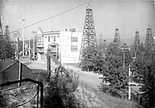
Accumulations of oil and gas occur almost wholly within strata of the younger sequence and in areas that are within or adjacent to the coastal belt.