Los Angeles flood of 1938
The flood was caused by two Pacific storms that swept across the Los Angeles Basin in February-March 1938 and generated almost one year's worth of precipitation in just a few days.
Due to the arid climate, soils are too hard to absorb water quickly during storm events, resulting in large amounts of surface runoff.
[4] Between February 27 and 28, 1938, a storm from the Pacific Ocean moved inland into the Los Angeles Basin, running eastward into the San Gabriel Mountains.
[1] Fifteen hours later on March 1, at approximately 8:45 PM, a second storm hit the area, creating gale-force winds along the coast and pouring down even more rain.
The Pacific Electric rail system, serving Los Angeles, Orange, San Bernardino, and Riverside Counties, was out of service for three weeks.
[7] The water surged south, inundating Compton before reaching Long Beach, where a bridge at the mouth of the river collapsed killing ten people.
The Los Angeles Times chartered a United Air Lines Mainliner to provide them an aerial view of flooding damage.
The reporter remarked: "Disaster, gutted farmlands, ruined roads, shattered communications, wrecked railroad lines—all leap into sharp-etched reality from that altitude.
"[8] Communities and mining operations in the San Gabriel Mountains such as Camp Baldy were destroyed, stranding hundreds of people for days.
Sam Browne, dam keeper during the 1938 flood, wrote that "Large oak trees several hundred years old rushed down the canyon like kindling...
The floodwaters poured into the reservoir of the still incomplete San Gabriel Dam, filling it over the night of March 2-3 and overtopping the emergency spillway.
[1][15] In Azusa, four spans of the 1907 "Great Bridge" along the Monrovia–Glendora Pacific Electric line, which had survived the San Gabriel's seasonal flooding for over 30 years, were swept away in the torrent.
[4] The Southern Pacific Railroad main line over Tehachapi Pass was closed for two weeks, requiring emergency service via buses and trucks.
[1] The Sepulveda Dam was built in 1941 to prevent the Los Angeles River from flooding the lower San Fernando Valley, Burbank and Glendale.
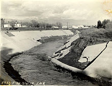
[1] About 278 miles (447 km) of streams in the Los Angeles River system were encased in concrete, a huge undertaking that took twenty years to complete.
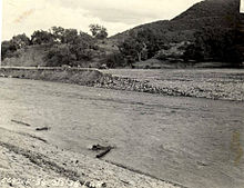
[5] The San Gabriel and Santa Ana Rivers were also ultimately channelized to protect against future floods, although it took much longer for those projects to be completed.