Lost Dutchman's Gold Mine
The mine is named after German immigrant Jacob Waltz (c. 1810–1891), who purportedly discovered it in the 19th century and kept its location a secret.
Years later, a man called Dr. Thorne treats an ailing or wounded Apache (often alleged to be a chieftain) and is rewarded with a trip to a rich gold mine.
A lack of historical records leaves uncertainty as to whether a Peralta family ever had possession of land, or mines, in or near the Superstition Mountains.
[7] A man named Miguel Peralta and his family did operate a successful mine in the 1860s – but near Valencia, California, not in Arizona.
Dr. George M. Willing Jr. paid Peralta $20,000 for the mining rights for an enormous swath of land – about 3,000,000 acres (12,000 km2) in southern Arizona and New Mexico – based on a deed originally granted by the Spanish Empire in the 18th century.
Since James Reavis, "the Baron of Arizona", was convicted of fraud when the Peralta family genealogy and other documents to support the land grant (and a barony associated with that land) were determined to be forgeries it also raises questions about the original purchase of the land grant by Dr. George M. Willing Jr. (the transaction had supposedly occurred at a primitive campsite to the southeast of Prescott without the benefit of the typical documentation; instead of a notarized deed, the conveyance was recorded on a piece of greasy camp paper bearing signature of several witnesses).
Another detail which casts doubt on the story is the fact that, according to Blair, there was never any Dr. Thorne in the employ of the Army or indeed of the Federal Government in the 1860s.
Blair contended that this story can be divided into "hawk" and "dove" versions, depending on whether the German(s) are said to behave violently or peacefully.
Waltz is attacked and wounded by marauding Apaches, but survives at least long enough to tell a man called Dr. Walker about the mine.
Waltz is also said to make a deathbed confession to Julia Thomas, and draws or describes a crude map to the gold mine.
Erwin passed the information to his father Adolph, who had a long-standing interest in lost mines and amateur exploration.
The elder Ruth had fallen and badly broken several bones while seeking the lost Pegleg mine in California.
After traveling to the region, Ruth stayed several days at the ranch of Tex Barkely to outfit his expedition.
Many of Ruth's personal effects were found at the scene, including a pistol (not missing any shells) and the metal pins used to mend his broken bones.
While this theory did not ignore the two holes in the skull, it did fail to explain how Ruth had managed to remove and bury the empty shell, then reload his gun, after shooting himself through the head".
[26]) Blair noted that the conclusion of the Arizona authorities was rejected by many, including Ruth's family, and "those who held onto the more romantic murdered-for-the-map story".
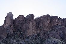
In 1977, 292 acres (118 ha) abutting the Tonto National Forest were set aside as the Lost Dutchman State Park.
The short "Discovery Trail" is a clear route with several placards giving the natural history of the area.
In 2023, a Cryptographer named James Simpson decoded the Ciphers of the pamphlet published in 1885, by JB Ward, a Confederate Cartographer.
Mentioning his homestead along the Green River Basin, it showed details behind the directions to take through a canyon to find a "Cave of Millions", known today as the fabled Lost Dutchman Gold Mine.
In the Ciphers authored by James Reavis, ringleader of the Peralta Land Grab, a dual-use system was created of the base numbers listed, and with the key using a seres of 111 ascending alphabets, climbing to the number 2906 in the 112th alphabet, the substitution produced a resulting page of plaintext letters, which were found to conceal Old English Box Ciphers.
With a second set of Box Ciphers interwoven into the page, it showed an outline of a trail with landmarks starting at the base of a dam near a shallow fenn or ford.
The trail was marked with a starting point using the older Cursum Perficio map, from the era of Spanish Exploration and the excursions that they had made into the many canyons of the Tonto Mountains.
Taking it's course across the Rio Salado near the base of the present-day Stewart Dam, it weaves through a labyrinth of trees, and in between three large mounds into the main sections of the trailhead.
A final pillar on the side of the trail in the shape of a man's head and face would be used to locate the entrance to the mine.
Seldomly used as the waters released from the dam create an impassible obstacle, the Gateway Trail has a significantly obvious route that follows into the canyon with a left-banking turn at the split in the dry river bed, carrying on for another 1000 yds.
They all feature the name of the river as the Rio Salado on them, further confirming the locations of the mines, as well as being originally used by the Spanish, dating back to an unrecorded period in the history of the Superstition Mountains.
As the discovery of these specific locations found encrypted in the ciphers of the Beale Papers were confirmed, it revealed that a number of later explorations had been made there to harness their wealth, leading eventually to the deaths of many well-known explorers, like Adolph Ruth, and Frank Fish, who were both familiar with the region and had access to the original maps that were passed along by the Spanish.