Louth Navigation
The act did not provide the normal provisions for raising capital for the construction, as finance could only be obtained by leasing of the tolls.
When complaints were received, a new act of Parliament was obtained in 1828 to alter the tolls and legalise Chaplin's long lease.
The operation was a moderate success until the beginning of the 20th century, when there was a rapid decline in income, and the canal formally closed in 1924.
Realising that a link to the North Sea would provide opportunities for trade and expansion, in October 1756 they commissioned the engineer John Grundy Jr. to survey a route.
He suggested a route from Louth to Tetney Haven, and on 28 January 1760, subscriptions were invited to pay for a full survey and an act of Parliament.
Smeaton advised caution, suggesting that they obtained the consent of as many landowners as possible before proceeding with a bill, as opposition in Parliament could be difficult to counter.
[5] Hogard then took over from Grundy as Chief Engineer, at a salary of £140 per year, and began the construction of the final section including seven locks.
[4] Additional subscriptions had to be found to fund the work, but the navigation reached Riverhead basin at Louth, and a formal opening was held in May 1770.
When the mill was not in use, water levels were topped up through a 4-foot (1.2 m) diameter culvert, which passed under a stables and granary to reach the basin.
[6] Initially, the commercial community around Riverhead was separate from the main centre of population in Louth, but after the coming of the railway, ribbon development resulted in the two areas being connected.
On paper, this appears to have been accepted, but it is not clear that it was carried out, since George Chaplin, the son of Thomas, paid for the navigation to be made wider and deeper in 1811, and spent another £400 on repairs in 1814.
c. cxiii) which allowed them to purchase the lease of the Louth Navigation, and later the same year, the Great Northern Railway Company (GNR) obtained another act of Parliament[which?]
[14] The early years of the 20th century saw a rapid decline in the use of the canal and the First World War killed what traffic was left.
[17] Most of the flow from the River Lud is fed into the canal,[19] and the Environment Agency maintain a tilting weir at the site of the original Top Lock.
This controls water levels in the Riverhead Basin, and also includes a gauging station which measures the flow along the canal.
Large volumes are also pumped from a feeder into Covenham Reservoir, from which it is treated and fed into the public water supply.
In summer months, the available supply is not always sufficient to meet the demand, and additional water is pumped along a 36-inch (914 mm) pipeline from the Great Eau.
The pumping station is located at Cloves Bridge, to the east of Saltfleetby All Saints, and the 6.8-mile (11 km) pipeline empties into the canal below the site of Outfen Lock.
[22] The Louth Navigation Trust was formed in 1986 as a registered charity, with the primary aim of preservation, conservation and restoration of the canal and of the buildings associated with it, including the lock structures.
They are based at the Navigation Warehouse at Riverhead, Louth, which they helped to restore to a high standard in 1998/9, in partnership with Groundwork Lincolnshire.
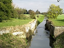
[23] The Louth Navigation, unlike many other disused canals, is in water throughout its length and has not been in-filled or built over as it is important for drainage of the surrounding land.
To the west is Navigation Warehouse, a rectangular building with five bays and three storeys, constructed of red brick with a pantile roof.
[25] Baines Flour Mill, which supplied water to the basin, is a red-brick building, dating from around 1800, with hipped pantile roofs.
The third section is partially hidden by a twentieth century concrete bridge, which carries a minor road over the lock chamber.
[37][38] The canal then passes the church of St Mary, once the chapel for a Gilbertine Priory, which dates from the eleventh to fourteenth centuries.
Before closure to navigation, there was another inverted syphon under the canal, which returned the water to the River Lud, but this has been blocked up and abandoned.
[44] These, and the other pumping stations that discharge into the canal are owned and operated by the Lindsey Marsh Internal Drainage Board.
[45] Biergate East and West pumping stations[46] are situated near Covenham Reservoir, constructed in the 1960s to supply drinking water.
[47] The works to treat the water is near Fire Beacon Farm and bridge, the temporary terminus of the opened waterway during construction.
[49] The final section is now protected from high sea levels by an outfall sluice at Tetney Haven, with two sets of pointed doors.