Loutre River (Missouri River)
During archaeological excavation by the University of Missouri from 1949 to 1955, the cave yielded evidence of ancient Dalton and Archaic Period Native Americans.
Benton bragged of the Loutre Lick spring in the halls of Congress, where Henry Clay referred to him as the "Senator from Missouri's Bethesda."
The Army established Fort Clemson on Loutre Island as a base of operations to protect American settlers.
On March 7, 1815 Captain Callaway and three soldiers (James McMillin, Parks Hutchings, Frank McDermid) were killed after pursuing Sauk and Fox Indians who had stolen horses from settlers.
Captain Callaway, with Lieutenant Riggs and fourteen men left Fort Clemson, on Loutre Island, in pursuit of the Indians.
While they first recaptured the horses about 12 miles away guarded mostly by women, the Army group was later fired upon by the Indian warriors.
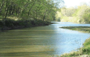
Isaac Van Bibber's house in Mineola has a continuous spring that flows year round through its original rock basement.
One mile north of McKittrick on Missouri State Route 19 the 180 grave Loutre Island Cemetery can be found.
This is an African-American cemetery, named as a result of being on an actual island of the Loutre River at the time of its inception in 1804.
Today the Missouri River is much narrower than it was at the time of the cemetery's inception in the early 1800s when it was over 1½ miles wide at this point.
An African-American settlement was founded around 1800 commonly called Little Africa on one of the county's highest points at almost 1,000 feet of elevation overlooking the Loutre River near McKittrick.
As a result of this position, first adopted in the 1840s, Hermann became a center for the mustering of black troops into the militia for the Civil War.
After the waste release, which occurred over a five-day period, the EPA said 53,000 fish were killed along a five-mile stretch of the river.
The forest, cropland, and old fields also provide for good public deer, dove, quail, rabbit, squirrel, turkey, and waterfowl hunting.
The appearance of blacknose shiner is considered a marker of very high water quality and pristine stream conditions.
The Katy Trail State Park, a 225-mile-long former railroad bed converted to public use, crosses the Loutre River at McKittrick by means of an iron truss bridge built by the A.P.
St. Peter Sandstone is believed by geologists to have formed the coast line of a prehistoric sea stretching from Minnesota through Iowa, Illinois, and Missouri.
Highway engineers have to correct the steep grade while preserving the many historic and environmentally significant sites that surround it, including Slave Rock, the Loutre River, Graham Cave, Danville Glades Conservation Area, and others.
The breach of the eastern bank levee of the Loutre just south of the Katy Trail crossing at McKittrick created two large permanent lakes and washed out Missouri State Route 19.