Lower Hutt
Lower Hutt (Māori: Te Awa Kairangi ki Tai)[4] is a city in the Wellington Region of New Zealand.
Before European settlement, thick forest covered most of the Hutt Valley, with areas of marshland close to the river's mouth.
The first immigrant ship, the Aurora, arrived on 22 January 1840, an event still commemorated every year on the Monday closest as Wellington's Anniversary Day.
A settlement, Britannia, grew up close to the mouth of the Hutt River (Te Awa Kairangi in Māori language), and settlers set up New Zealand's first newspaper and bank.
[6] In the 1840s an area on the west bank of the Hutt River, in what is now Alicetown, formed the village then known as Aglionby.
[6] The 1855 Wairarapa earthquake (in the range of magnitude 8.1 to 8.3) raised part of the lower valley, allowing reclamation of land from swamp.
Campbell Barry became New Zealand's youngest mayor[10] and was first elected in 2019, succeeding Ray Wallace.
In 1987–1989 the New Zealand Government forced local authorities to consolidate, which led to Lower Hutt amalgamating with the adjacent Boroughs of Petone and Eastbourne and with the Wainuiomata District (which had its independence for barely a year), and to the abolition of the Hutt County Council.
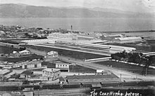
The valley widens into a delta as the river nears its mouth, so the central urban area of the city forms a triangle with its longest side along the shoreline.
[16] Lower Hutt includes the cluster of small settlements that extend down the eastern coast of Wellington Harbour.
The city also includes a large area of sparsely-populated land to the east of the harbour, extending to Pencarrow Head and into the Remutaka Range.
Smaller streams and storm-water drains have also caused occasional problems when rainfall exceeds average levels.
With lower river-levels in mid-summer, algal blooms have contributed to making slow-flowing areas anoxic.
The Regional Council has cited the algal blooms as the cause of death of a small number of dogs swimming in the river, as well as of skin reactions in the case of swimmers.
[25] In the five years between the 2013 and 2018 censuses, the population grew steadily across the city with an increasing amount of homes being purchased and the area seen as more affordable comparable to the rest of the region.
Lower Hutt remains the main location for light industrial activity in the Wellington Region.
Until post-war housing development took over, the central and northern areas of the city were largely market gardens.
In 2010 the lower reaches of the Waiwhetū Stream was cleaned up to remove toxins from decades of industry use.
Lower Hutt has one of the greatest proportion of science, technology and high value manufacturing businesses in New Zealand.
After 1989 most of TVNZ's operations moved to Auckland, and the studios were eventually sold off in 2012 to a consortium of Wellington investors.
A large proportion of Lower Hutt's residents commute to the mainly commercial, service and government offices in Wellington City 12 km to the south-west.
[43] The city possesses civic administration buildings constructed in the 1950s that are regarded as representative architecture of the era.
It is a prime example of early colonial architecture in New Zealand and operates today as a tourist attraction.
The city is popular for outdoor sports, especially mountain biking, hiking, recreational walking and fishing.
[45] The Riverbank car park adjacent to the central city is home to a Saturday produce market.
[46][47] Among the filming locations for The Lord of the Rings directed by Peter Jackson, Dry Creek quarry, which dominates the hills above the suburb of Taitā, became the site for a huge medieval castle built for scenes of Helm's Deep and Minas Tirith.
The station can be heard in Lower Hutt on 87.9 MHz FM with simulcasting via their official website.
The western hills have been populated as residential areas, but the eastern side is protected and clad in native bush and scrub, and the ubiquitous gorse in areas that have been cleared as a result of scrub fires or earlier human activity.