Lucin Cutoff
The most prominent feature of the cutoff was a twelve-mile-long (19 km) railroad trestle crossing the Great Salt Lake, which was in use from 1904 until the late 1950s, when it was replaced by an earthen causeway.
By going west across the lake from Ogden to Lucin, it cut 44 miles (71 km) off the original route and also significantly decreased curvature and grades.
When the line opened, it included short causeways extending from the western shore of the lake and the edge of Promontory Point, connected with a nearly twelve-mile-long (19 km) wooden trestle.
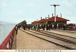
[2] In 1941, the telegraph building at the Midlake station was reopened as part of World War II related military operations.
[3] In 1942, the original track between Lucin and Corinne, Utah was removed, including the remaining spikes on Promontory Point, and the scrap metal was donated to the war effort.
In the early 1980s, Utah experienced heavy flooding, and much of the extra water along the Wasatch Front flowed into the Great Salt Lake.
To aid the two culverts in channeling water to the northern arm, the State of Utah constructed a 300-foot-long (90 m) bridge at the western end of the causeway.
During the flooding of the 1980s, this buildup included placing 1,430 surplus railcars along the northern edge of the causeway and filling them with rock to act as gabions (this feature is known as the "Boxcar Seawall.
Construction of a 180-foot-long (55 m) bridge was completed in fall 2016, although the railroad agreed to delay opening the breach for a few months, due to environmental and water level concerns.
[16] Due to the Southwestern North American megadrought, the amount of fresh water flowing into the southern arm of the lake had dropped significantly enough that, during the summer of 2022, a 4-foot-high (1.2 m) berm was constructed in the breach beneath the 2016 bridge.
As of 2024, it is the policy of the Office of the Great Salt Lake Commissioner to raise the berm anytime the southern arm's level falls to 4,190 feet (1,280 m) or lower.