Great Salt Lake
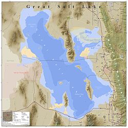
In 2021, after years of sustained drought and increased water diversion upstream of the lake, it fell to its lowest recorded area at 950 square miles (2,500 km2), falling below the previous low set in 1963.
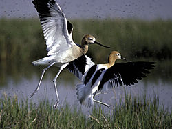
The lake has been called "America's Dead Sea"[4] and provides a habitat for millions of native birds, brine shrimp, shorebirds, and waterfowl, including the largest staging population of Wilson's phalarope in the world.
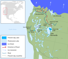
[2] Bonneville reached 923 ft (281 m) at its deepest point[6][7] and covered much of present-day Utah and small portions of Idaho and Nevada during the ice ages of the Pleistocene Epoch.
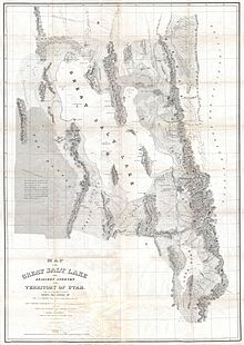
[8] The Great Salt Lake entered written history through the records of Silvestre Vélez de Escalante, who learned of its existence from the Timpanogos Utes in 1776.
Fremont's glowing reports of the area were published shortly after his expedition, and they influenced the choice of Brigham Young and other members of The Church of Jesus Christ of Latter-day Saints to settle in the Salt Lake Valley in July 1847.
[12] Beginning in November 1895, artist and author Alfred Lambourne spent a year living on the remote Gunnison Island, where he wrote a book of musing and poetry, Our Inland Sea.
[22] In 2023, scientists at Brigham Young University estimated that without policy changes, the lake would dry up in 2028, with local species killed off by overly salty water somewhat before that.
Because no rivers, except a few minor streams, flow directly into the north-west arm, Gunnison Bay, it is substantially saltier than the rest of the lake.
The lake-effect snowfalls are more likely to occur in late fall, early winter and spring, due to the higher temperature differences between the lake and the air above it.
[33] The lake level change is strongly modulated by Pacific Ocean-coupled ocean/atmospheric oscillations at low frequency and therefore reflects the decadal-scale wet/dry cycles that characterize the region.
The brine flies have an estimated population of over one hundred billion and serve as the main source of food for many of the birds which migrate to the lake.
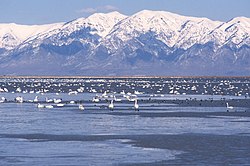
[51] However, the fresh- and salt-water wetlands along the eastern and northern edges of the Great Salt Lake provide critical habitat for millions of migratory shorebirds and waterfowl in western North America.
[52] Some of the birds that depend on these marshes include:[53] Wilson's phalarope, red-necked phalarope, American avocet, black-necked stilt, marbled godwit, snowy plover, western sandpiper, long-billed dowitcher, tundra swan, American white pelican, white-faced ibis, California gull, eared grebe, peregrine falcon, bald eagle, plus large populations of various ducks and geese.
There are twenty-seven private duck clubs, seven state waterfowl management areas, and a large federal bird refuge on the Great Salt Lake's shores.
[54] Wetland/wildlife management areas include the Bear River Migratory Bird Refuge; Gillmor Sanctuary; Great Salt Lake Shore lands Preserve; Salt Creek, Public Shooting Grounds, Harold Crane, Locomotive Springs, Ogden Bay, Timpie Springs, and Farmington Bay Waterfowl Management Areas.
Access to Hat, Gunnison, and Cub islands is strictly limited by the State of Utah in an effort to protect nesting colonies of American white pelican (Pelecanus erythrorhynchos).
For example, a number of explorers who visited the area in the mid-1800s (e.g. Emmanuel Domenech, Howard Stansbury, Jules Rémy) noted an abundance of yellow-flowered "onions" on several of the islands, which they identified as Calochortus luteus.
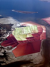
North of the causeway, the lake is dominated by Dunaliella salina, a species of algae which releases beta-carotene, and the bacteria-like haloarchaea,[61] which together give the water an unusual reddish or purplish color.
[60] The dense, high-salinity water of the North Arm flows back through the causeway into the Southern portion of the lake, creating a deep brine layer there.
[62] Although brine shrimp can be found in the arm of the lake north of the causeway, studies conducted by the Utah Division of Wildlife Resources indicate that these are likely transient.
The abundance of invertebrates such as gnat larvae (chironomids) and back swimmers (Trichocorixa) are fed upon extensively by the huge shorebird and waterfowl populations that utilize the lake.
He escaped from Salt Lake City's Tracy Aviary in 1987 and lived in the wild, eating brine shrimp and socializing with gulls and swans.
Fish and Wildlife Service researchers discovered a high level of methylmercury in the Great Salt Lake with 25 nanograms per liter of water.
The finding of high mercury levels prompted further studies,[69] and a health advisory warning hunters not to eat common goldeneye or northern shoveler, two species of duck found in the lake.
About 16% of the mercury is from rivers, and 84% is from the atmosphere as an inorganic form, which is converted into more toxic methylmercury by bacteria which thrive in the more saline water of the North arm affected by the causeway.
[62] A 2020 study found high concentrations of mercury in the lake's sediments, a consequence from smelting and mining activities in the surrounding mountains.
[15] Prior to December 2, 2016, the causeway constrained the flow of water between northern and southern arms, which has a significant impact on various industries surrounding the lake.
In the southern portion of the lake, where the vast majority of the fresh water inlets are found, the salt level can dip below what is necessary for the brine shrimp to survive.
There is also a problem with pollution from industrial and urban effluent, as well as a natural "lake stink" caused by the decay of insects and other wildlife, particularly when the shallow water is disturbed.
The unresolved circumstances surrounding her death have led to local legends suggesting that her spirit haunts the area, with reports of ghostly sightings and unexplained voices.