Ludwigshafen
The Rhine Neckar region was part of the territory of the Prince-elector of the Kurpfalz, or Electorate of the Palatinate, one of the larger states within the Holy Roman Empire.
Oggersheim in particular gained some importance, after the construction of both a small palace serving as secondary residence for the Elector, and the famous pilgrimage church, Wallfahrtskirche.
For some weeks in 1782, the great German writer and playwright Friedrich Schiller lived in Oggersheim, on flight from his native Württemberg.
The year 1844 was the official birth of Ludwigshafen, when Lichtenberger sold this property to the state of Bavaria (Bayern), and the military title of the fortress was finally removed.
On December 27, 1852, King Maximilian II granted Ludwigshafen am Rhein political freedom and as on November 8, 1859, the settlement gained city status.
Real growth began with industrialization, and gained enormous momentum in Ludwigshafen due to its ideal transport facilities.
In addition to its excellent position and harbor facilities on the Rhine, a railway connecting Ludwigshafen with the Saar coalfields was completed in 1849.
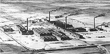
From then on, the city's rapid growth and wealth were linked to BASF's success and its expansion into becoming one of the world's most important chemical companies.
This population explosion looked quite “American” to contemporaries; it determined Ludwigshafen's character as a “worker's city”, and created problematic shortages of housing and real estate.
In the area between the city centre and those two suburbs new quarters (“North” and “South”) were built after (then) modern urban development plans.
When the war was lost by Germany in 1918, the left bank of the Rhine was occupied by French troops, in accordance with the terms of the peace agreement.
The economic recovery of the 1920s was marred by one of the worst industrial explosions in history when, on Sept. 21, 1921, a BASF storage silo in Oppau blew up, killing more than 500 people, injuring a further 2,000, and destroying countless buildings.
It prospered until 1929 and the onset of the Great Depression, which brought unemployment, labor trouble, political strife, and the rise of the Nazis.
Further, similar to Nazi plans in other cities (e.g. Hamburg), they aimed at creating a "Greater Ludwigshafen" by agglomerating smaller towns and villages in the vicinity.
In the early 1970s, a plan to reform the composition of the German Bundesländer, which would have created a new state around a united Mannheim-Ludwigshafen as capital with more than half a million inhabitants, failed.
The negative aspects of industrial success became obvious when examinations revealed the bad state of air and the Rhine due to pollution.
[12] One of the most annoying faults[citation needed] of Ludwigshafen – at least for many of the city's inhabitants - was its comparative lack of high-quality shopping possibilities.
It has attempted to repair this deficiency by creating a second large shopping mall on the southern tip of the city centre (the Walzmühle near Berliner Platz) with affiliated railway station (Ludwigshafen-Mitte).
Its northern and southern boundaries are the Hochstraßen (highways on stilts), the Rhine is in the East and the main station is located in the West of downtown Ludwigshafen, at a walking distance of about 15 minutes from the central pedestrian precinct Bismarckstraße that forms, together with the shopping mile Ludwigsstraße, the main North-South Axis, connecting the so-called “North Pole” with the Rathaus Center and the “South Pole” with Berliner Platz, the Walzmühle shopping centre and Ludwigshafen (Rhein) Mitte station.
Hemshof and “North” represent the “old town” of Ludwigshafen, they are known for their very high proportion of foreign inhabitants, making them culturally diverse.
18,000 inhabitants), west of Mundenheim, is (as the name “garden city” suggests) a very green suburb, dominated by flat roofed houses and some tower blocks.
The Wallfahrtskirche, a railway station, the important Unfallklinik (“casualty hospital”), and several large residential blocks are to be found in Oggersheim.
For the last few years, the northern subdistricts of Notwende and Melm have seen a large amount of building activities in their new housing estates.
Rheingönheim (ca 7,000 inhabitants), as the southernmost suburb of Ludwigshafen, is known mainly for its industry (Woellner) and its game enclosure Wildpark.
6,000 inhabitants), as the westernmost suburb, has long been a small agricultural village, but now it is growing rapidly due to new housing estates.
Ludwigshafen Hauptbahnhof is a huge train station, its impressive pylon bridge pier serving as the city's landmark.
A rather strange feature of Ludwigshafen's public transport system is the existence of four underground tram stations (Rathaus, Danziger Platz (closed since late 2008), Hauptbahnhof, Hemshofstraße).
The twin cities of Mannheim and Ludwigshafen closely cooperate in many areas; although they are separated by the Baden-Württemberg/Rhineland Palatinate boundary, this frontier is mainly an administrative one.
The district south of Ludwigshafen is dominated by the Rhine and the Altrhein arms (lakes marking the earlier course of the river) and the ancient town of Speyer with its magnificent imperial cathedral, a noteworthy and remarkable city.
The Kief’scher Weiher in the South is connected with the Rhine and serves as yacht harbour, being surrounded by weekend camping areas.