Lunar Reconnaissance Orbiter
[8] Its detailed mapping program is identifying safe landing sites, locating potential resources on the Moon, characterizing the radiation environment, and demonstrating new technologies.
[15][16] The first images from LRO were published on July 2, 2009, showing a region in the lunar highlands south of Mare Nubium (Sea of Clouds).
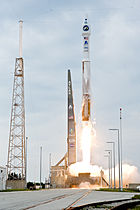
The one-day delay was to allow the Space Shuttle Endeavour a chance to lift off for mission STS-127 following a hydrogen fuel leak that canceled an earlier planned launch.
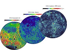
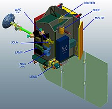
[25] Areas of investigation include selenodetic global topography; the lunar polar regions, including possible water ice deposits and the lighting environment; characterization of deep space radiation in lunar orbit; and high-resolution mapping, at a maximum resolution of 50 cm/pixel (20 in/pixel), to assist in the selection and characterization of future landing sites.
[26][27] In addition, LRO has provided images and precise locations of landers and equipment from previous and current lunar missions, including the Apollo sites.
[42] A series of four rocket burns over the next four days put the satellite into its commissioning phase orbit where each instrument was brought online and tested.
The Mini-RF instrument has already met its science mission success criteria by collecting more than 400 strips of radar data since September 2010.
[54] On August 21, 2009, the spacecraft, along with the Chandrayaan-1 orbiter, attempted to perform a bistatic radar experiment to detect the presence of water ice on the lunar surface,[55][56] but the test was unsuccessful.
[59] This volume of data is possible because the Moon is so close, LRO has its own dedicated ground station, and it doesn't have to share time on the Deep Space Network.
The images revealed splotches, small areas whose reflectance is markedly different from that of the surrounding terrain, presumably from disruption of the surface by recent impacts.
Their global distribution and orientation suggests that the faults are created as the Moon shrinks, with influence by gravitational tidal forces from Earth.
[63] In July 2024, the analysis of the radar data obtained by LRO confirmed the presence of an underground cave on the moon accessible from the surface.
Lunar Reconnaissance Orbiter · Earth · Moon

LRO · Moon